 |
Exploring
the social context of coastal erosion
|
| |
Exploring
the social context of coastal erosion
|
Paula Blackett, AgResearch, Hamilton, New Zealand. Email: Paula.Blackett@agresearch.co.nz
Terry Hume, National Institute of Water and Atmosphere (NIWA), Hamilton, New
Zealand.
Jim Dahm, Eco Nomos, Thames, New Zealand.
Paula BlackettAgResearch
|
Terry HumeNational Institute of Water and Atmosphere (NIWA) |
Jim DahmEco Nomos
|
Coastal erosion and its associated hazards to property and infrastructure and the debates that emerge over remedial measures cause conflict that requires negotiated solutions involving all key stakeholders. A series of New Zealand case studies is presented and indicates that positive or negative environmental outcomes are largely the result of how the negotiation proceeds, who is involved, how resource management agencies behave and the nature of the physical environment. Positive outcomes emerge when: Cooperative relationships are established, learning and trust are developed, risks are addressed, scientific input is managed, lobby groups are defused, contending interests are reconciled, and records are kept of the negotiation process and agreements reached.
Coastal erosion is a natural process that becomes a hazard or a problem when it poses, or is perceived to pose, a threat to things that humans value (Ricketts, 1986). Yet, notwithstanding the risk posed by coastal erosion in many New Zealand localities, there is a strong desire to live close the coast because of its high aesthetic and recreational value. How to address coastal erosion is a challenge for many coastal communities because there is debate about alternative remedial measures, resulting in conflict that needs to be resolved. A series of New Zealand case studies is presented to understand the coastal erosion issue and identify the factors that determine how best to achieve positive environmental outcomes which preserve the natural character of the coast. In this paper, positive environmental outcomes are equated with the retention of natural character because this is described as a matter of national importance under New Zealand’s guiding environmental legislation.
New Zealand has a coast that is highly dynamic and varied, with shorelines that are constantly shifting in position as a result of changing sediment supply, wave attack, gradual changes in sea level associated with climate change, tectonic movements and local factors including human intervention (Goff, 2003; Healy & Kirk, 1982; Hume & Herdendorf, 1988). Many of the earlier coastal settlements were located too close to the sea to accommodate these changes. Moreover, in some places human interference in natural coastal dynamics and the function of beach systems has made things worse (Pilkey & Hume 2001). When coastal erosion or storm events threaten private property, valued community assets or a popular beach the community demands (from local government) some action to protect their interests. The perceived solutions, presented by affected parties, are as diverse as the range of values associated with the coast (Becker et al., 2007; Blackett & Hume, 2006). Central to debates about how to manage coastal erosion is the challenge of reconciling the interests of those whose private property is at risk from coastal erosion and public interest in community safety and sustainability. It falls to local government to work with the community, within the constraints imposed by the Resource Management Act (1991) (RMA) and other relevant legislation, to develop an appropriate strategy given the situation at hand. This is never a straightforward process.
Cooper and McKenna (2008) suggest that when an erosion event occurs the choices are to either “intervene, accept or adapt,” or as the Inter-governmental Panel on Climate Change (IPCC) put it, “protect, accommodate or retreat” ( Klein et al., 2001; Nicholls et al., 2007 ). Traditionally, interventions have been dominated by a paradigm that focuses on ‘holding the line’ (i.e., a “protect” approach) by using shoreline armouring and engineering structures. More recently, there has been a move to use “environmentally soft” or “soft engineering” methods such as beach nourishment and dune restoration (Klein et al., 2001). This reflects a shift away from a “humans against nature” ethos towards a more integrated ecosystems based approach (Kay & Alder, 2005) which is, in essence, about managing humans rather than beaches. This paradigm shift has gained momentum in the light of the predictions that climate change may aggravate coastal erosion and flooding and the associated adverse affects of some coastal engineering structures; and increased emphasis on sustainability and concerns about the resilience of coastal settlements (Nicholls et al., 2007). Nevertheless, how much this paradigm shift is reflected in practice is unclear. Adaptation and acceptance of natural coastline fluctuations may involve managed retreat (i.e., relocation) of community and private assets out of the erosion prone area over the course of time (Cooper & McKenna, 2008). Application of this approach is constrained by the nature of the assets and the extent of the human settlements at risk (Nicholls et al., 2007).
Each approach to managing coastal erosion has a different distribution of benefits and costs within the community at local, regional and national scales (Cooper & McKenna, 2008). Hard engineering options (e.g., a sea wall) may protect community or private assets (within design parameters) but the beach in front of the structure is likely to erode, resulting in potential loss of the beach. In such a case, beach amenity and use for locals and visitors are lost in favour of protecting homes and or infrastructure; and significant downstream impacts may also occur. Managed retreat on the other hand will see beach amenity and public use protected at the expense of property and or infrastructure. Soft engineering options can potentially maintain both the beach and protect property, however, success is highly dependent on the nature of the physical environment, the affordability of the mitigation measures and successfully negotiating an outcome that reconciles different contending interests. Of course, protection, accommodation or retreat are not mutually exclusive options. In reality, a combination of approaches over time may be appropriate. The selection of coastal erosion mitigation strategies is complex because the chosen strategy must manage both the physical environment and the trade-offs between numerous values and interests in the coastal marine area at local, regional and national scales. Furthermore, the chosen strategy must be affordable and equitable. What constitutes an appropriate solution is, however, highly contested, with multiple stakeholders having very different interests and agendas. Invariably, the final outcome is a product of how these interests are addressed through a public decision-making process. Six New Zealand case studies will be examined to understand the coastal erosion issue and identify the factors shaping the outcome of efforts to mitigate the associated impacts. The next section provides an overview of how the New Zealand coastal environment is managed and the nature of coastal communities.
The main legal provisions governing the coastal environment
The RMA is the key piece of piece of legislation governing coastal management in New Zealand. The Act has a sustainable management focus and requires anyone exercising powers under the Act to “recognise” and “provide for” the preservation of the natural character of the coastal environment (including the coastal marine area), wetlands, lakes and rivers and their margins, and their protection from inappropriate subdivision, use, and development” (s6(a)). The RMA makes provision for a hierarchy of policies and plans at the national, regional, district and city level which are used to govern coastal activities. At the national level, the Department of Conservation (DoC) has prepared a mandatory New Zealand Coastal Policy Statement (NZCPS) (Department of Conservation, 1994). Recently, the NZCPS was reviewed and the intention is to update the policy statement (Department of Conservation Policy Group, 2008) to account for current issues in the coastal marine area. At the time of publication, the proposed changes to the NZCPS were still under review. Although the proposed NZCPS provides stronger direction for dealing with coastal erosion issues than its predecessor (Department of Conservation, 1994 ; Department of Conservation Policy Group, 2008) , it is difficult to know how the review process will influence the final document. Regional councils, unitary authorities and district and city councils are responsible for the day to day application of the RMA. Regional councils are required to sustainably manage natural and physical resources (including biodiversity, water, soil and air) while district and city councils focus more on land use activities (e.g., subdivision). Activities in the coastal marine zone which are not permitted in the hierarchy of plans must go through a resource consent process. Applications for restricted coastal activities require a public hearing presided over by a hearings committee that will include an appointee of the Minister of Conservation. The committee will make a recommendation to the Minister. This recommendation may be appealed to the Environment Court, which in turn reports to the Minister. The Minister then makes the final decision on the application. The public can make their concerns known at several stages in the policy and planning processes; in particular, through submissions on the draft NZCPS as part of the review process; as well as at various stages of local authority policy and plan-making processes. In addition, any affected party can prepare a submission on any proposed activity as it passes through the resource consent process. Further opportunities for public involvement in council decision-making exist through the provisions of, among other things, the Local Government Act (2002), e.g., consultation opportunities in the preparation of The Long Term Council Community Plan (LTCCP). Although the LTCCP does not specifically deal with activities in the coastal environment on a day-to-day basis it does allow the public to take part in creating a future vision for the coastal environment (Wilson & Salter, 2003). City and district councils can issue building consents for structures, coastal defences and domestic dwellings in accordance with provisions in the Building Act (2004), which also has provisions for making publicly available information about hazard risks associated with specific properties through Project Information Memoranda.
New Zealand Coastal Communities
Coastal communities in New Zealand are a very diverse mix of residents, absentee owners (beach home owners) and household income and age groups (Becker et al. 2007; Stewart, et al., 2005). Cheyne & Freeman (2006) suggest the composition of many coastal communities has changed in the last few years as a result of amenity based purchase of second homes (holiday homes, baches or cribs) or a counter-urban movement by those seeking a lifestyle change. This ‘sea-change phenomenon’ (Burnley & Murphy, 2004) has numerous social impacts (Cheyne & Freeman, 2006) which are particularly relevant in a study on the social context of coastal erosion. Of particular relevance, are increasing property values buoyed by a high demand for coastal property (Cheyne & Freeman, 2006). Many small coastal baches have been replaced with much larger and more valuable dwellings. As a result, beachfront property represents a significant financial investment. According to Turbott & Stewart (2006), many owners expect to use their property in perpetuity regardless of whether or not the property is at risk from coastal erosion. It is likely that inadequate attention is focused on such risk when people buy beachfront property and undertake significant property development (Bin & Kruse, 2006; Dahm, 2003; Turbott & Stewart, 2006). In the Waikato region, for example, many people think that coastal erosion will not happen in their community within the next 20 years (Stewart et al., 2005). Many sandy shorelines in New Zealand are in long term retreat (Pilkey & Hume, 2001) , but, even where the impact of coastal erosion is already evident, the risk associated with coastal erosion may not be understood or taken into account. For most people, concern about coastal erosion arises only after an event (such as a coastal storm) threatens something they value (Cooper & McKenna, 2008). Beachfront property owners who have been impacted or perceive themselves to be under imminent threat are then likely to take concerted action to protect their property and the associated financial investment; notwithstanding potential impacts the protective measures might impose on other stakeholders, for example, those who wish to maintain beach amenity and the natural character of the coast, or property owners downstream that might experience adverse impacts due to protective measures. Conflict inevitably arises and may become intractable because of the significant interests at stake. Understanding the social context of such conflicts sheds light on key factors affecting the choice of erosion mitigation strategy, and how the public decision-making process determines the outcomes of such choices.
Issues surrounding community involvement in coastal erosion management are explored at six locations in New Zealand to identify the factors that contribute to retaining or losing “natural character” of the coastal environment, as defined in the RMA in section 6. According to Dahm (2000) , natural character includes natural features (i.e., landforms, indigenous and introduced flora and fauna) and natural processes (both physical and biological). All coastal environments retain some degree of natural character although increased human modification reduces “naturalness”. Situations that resulted in retention of natural character are described as positive environmental outcomes whereas loss of natural character is considered to be a negative environmental outcome. ‘Soft’ mitigation options, like dune re-vegetation or managed retreat, are thus deemed positive environmental outcomes because they do not impact on natural character, are consistent with many district plans and do not reduce the public amenity value of the coast. Negative environmental outcomes result from mitigation measures that adversely affect natural character e.g., because of shoreline armouring (or some other hard engineering option). Such ‘hard’ engineering approaches may succeed in stopping the shoreline from retreating further (and thus protect beachfront). But they typically lead to a loss of high tide beach and natural character of the area, and may also cause significant downstream impacts. In addition to considerations about natural character, the choice of mitigation strategy obviously has important social, cultural, aesthetic and economic impacts. The latter are not the focus of this study.
Six case studies (Urenui, Mokau, Marokopa, Muriwai, Mangawhai and Bay of Plenty) were selected based on three criteria. Firstly, the community had experienced a beach erosion event which threatened local values or property within recent memory. Secondly, there was a body of scientific knowledge about the behaviour of the beach system over time. Finally, a history of community action and past decisions was available though key informants and secondary data sources such as council records, technical reports and newspapers. Unstructured face to face interviews (Kitchin, 2000) were selected as the most appropriate way to collect information about the social context of the erosion events and the choice of mitigation measures. This research is exploratory but these case studies help to shed light on key factors shaping environmental outcomes based on participants’ experiences in making decisions to manage coastal erosion. Interviewees were selected to represent the array of stakeholders and interests involved in, or familiar with, negotiating the outcome at each site, and included participants from local government (four), technical specialists (three) and local communities (nine). Technical specialists and participants from local government were familiar with more than one of the case studies. Each participant was interviewed at their home or place of work. Interviews took between one and a half and four hours, and each interview was recorded and transcribed. This paper provides a succinct overview of each case study and then presents a synthesis of the key factors influencing the final environmental outcome. Although every effort has been made to avoid identifying interviewees, the circumstances and nature of the information provided may result in their identity being apparent to some. All those interviewed found this acceptable.
The details of each case study (see Figure 1) are briefly summarised in the following sections from a physical and social perspective, informed by a literature review and participant interviews.
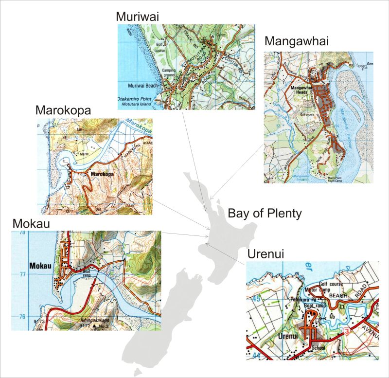
Figure 1. Locations of the six case studies on the west and east coast of the North Island of New Zealand.
Urenui Beach is a small (0.5 km long) steep, reflective, black sand beach at the mouth of the Urenui River on the west coast of the North Island (Figure 1). It receives the full force of ocean swell generated to the south of New Zealand as well as shorter period waves generated in the Tasman Sea. While there are large movements of sand on and off the beach in response to changes in the wave climate, the total volume of sand in the system is small and at the southwestern end of the beach a rock platform is exposed on occasions when the sand is stripped by waves. There is strong longshore transport of sand from west to east along the shore and the shoreline is very mobile at the river mouth. A strip of council owned public land some 300 to 400 metres wide behind the beach contains baches (constructed in the 1940’s and 1950’s on long term lease land) at the western end and a very popular public golf course at the eastern end. Public access to Urenui beach was restricted by the baches and golf course. Erosion over the last 30 years has threatened the baches and the only Par 5 hole on the golf course. This threat, coupled with 30 years of council inaction and a growing community concern about coastal erosion, resulted in the formation of a lobby group to push for shoreline armouring. Others were opposed to such protective works. Under increased pressure, the District Council employed a consultant to facilitate a process of community negotiation and recommend a potential solution. In the consultants view, the most appropriate solution was a ‘soft’ mitigation option involving managed retreat of the baches and redesign of the golf course including relocation of the Par 5 hole. This solution was seen to balance competing views and maintain the natural character of the beach. However, the majority of stakeholders involved in the community consultation process (mainly golf club members and bach owners) had interests in ‘holding the line’ and lobbied for a rock wall – overwhelming the opinion of the underrepresented wider community. This lobby group withdrew from the negotiation process and used political pressure (in a local body election year) to begin a consent application (to the Regional Council) for a publicly-funded seawall. In spite of an unfavourable Assessment of Environmental Effects, the Regional Council granted a temporary (10 year) consent for the construction of an $800,000 rock seawall along the front of the golf course. As a result, the wider community lost a high tide beach, the natural character was adversely affected and edge effects of the wall are impacting the adjacent un-armoured section of the beach. A summary of the influences driving what is perceived to be a negative environmental outcome at Urenui is illustrated in Figure 2.
Muriwai Beach forms the southern end of a long dissipative, black sand beach on the west coast (Figure 1). It receives the full force of long period ocean swell generated to the south of New Zealand as well as shorter period waves generated in the Tasman Sea. There are large movements of sand on and off the beach in response to changes in the wave climate and the level of the beach rises and falls about one to three metres as a consequence. The dunes are eroded and scarped along the shore. There is strong longshore transport of sand from south to north along the shore.
Since the 1960’s, Muriwai beach has been eroding with the shoreline retreating around one metre per year. Erosion has threatened mainly Regional Council public park infrastructure, including a car park, the surf club, the surf club tower, a golf course and roading. Past attempts to control the erosion include a seawall constructed by the Army around 20 years ago to protect one of the car parks and, more recently, constructed defences of gabion baskets and tipped rock to stop erosion where the road and boat ramp enter the beach. The Regional Council engaged a consultant to facilitate a solution with local stakeholders. This third party involvement was important to counteract some distrust amongst locals of the council and its long term plans for the beach front. The consultant established a process where all stakeholders were represented (local, councils, wider community groups, surfers etc.). Stakeholders were not committed to any preconceived outcome. What is interesting about this situation is that the most vocal stakeholders and the wider community both wanted to retain the natural character of the beach – quite a different situation to Urenui. The end result was a managed retreat solution through staged implementation with assets to be relocated away from the seashore when certain trigger points are reached. This solution provides time to conduct further investigations, get the required resource consents and for the community and beach users to adapt to change. Moreover, it allows for the unpredictable nature of coastal erosion. This solution has now been written up as a formal strategy and hazard lines have been formalised. The surf club has already been moved inland and fortunately council reserve land is available to accommodate all future infrastructure moves. Community relations with the Regional Council improved as a result of this process and now the council continues to manage the reserve in a more inclusive manner giving the local community more say over what happens at their beach. A summary of the influences driving the positive environmental outcome achieved at Muriwai is illustrated in Figure 2.
Mokau beach fronts an 800 metre long sand barrier at the mouth of a tidal river (Figure 1). The dunes are high (10 m) and the barrier well vegetated except at the south tip where the sea washes over. The coast is very energetic and the beach subject to cycles of erosion and accretion driven by southern ocean swells and strong prevailing winds from the south west. Sand bars at the river mouth are highly mobile and shift about in response to changes in wave climate and river floods. As the bars shift the protective screening from wave energy that they provide to the beach comes and goes, and waves and currents erode sand from the beach and dunes. As a consequence the level of the sand on the beach rises and falls one to two metres and the dunes get undercut by waves.
Erosion at Mokau has been recorded in roughly decadal cycles, separated by periods of beach accretion. Erosion became an issue in 1956 when the Crown subdivided the spit, against the recommendations of the local authority. In the 1960’s, an erosion event resulted in the loss of several sections and compensation was provided by the Government. Since that time, many of the earlier sections have been subdivided and now contain modest holiday homes close to the edge of the dune. An event in 1995/96 threatened several beachfront properties, resulting in illegal sandbagging by residents to protect their properties. At this stage the Regional and District Councils began working with the community to find a solution. Coastal hazard mapping identified three risk zones (high, medium and low) and placed 12 houses in the high risk zone. Initial pressure from beachfront land owners was to build a sea wall to protect their investment, however, the wider community and both councils opposed this option because of the costs (to be covered through additional local rates) and loss of natural character of the beach. Some beachfront land owners became reconciled to ‘doing nothing’ once the nature of the hazard was explained and they realised they may get many more years use from their properties despite the threat of erosion.
Between the mid 1990’s and 2003 there were no significant erosion episodes and beach levels tended to build up. During this same time, the value of coastal properties nationwide increased considerably and many of the Mokau beachfront properties were sold for typically at least $100,000 more than previous sales. As a consequence, when the next erosion phase occurred in 2003/04, council staff found themselves facing the same scenario as in 1995/96 and started renegotiating options with the community and a significant number of new beachfront landowners who had brought property at a premium - despite the hazard warning (derived from the hazard lines which were drawn up for the community) specified on Land Information Memoranda (a council report detailing all information relevant to the property) of threatened properties. Despite general community awareness about the risk and previous decisions about how best to manage coastal erosion, the result of the renegotiation was much the same, namely to “do nothing.” But with increasing property values and no formal long term plan to resolve the issue, it is likely that future coastal erosion will compel action. About six properties are currently threatened by erosion and there are ongoing disputes about unconsented (thus illegal) protection works. Figure 2 illustrates the relative strengths of the influences leading to the ‘do nothing’ option at Mokau.
At Marokopa a one kilometre long sand barrier lies at the mouth of a tidal river and protects the inner estuary from swells from the Southern Ocean, Tasman Sea waves and prevailing winds from the south west (Figure 1). In the north the spit is only 200 metres wide and is comprised of very low dunes which have been washed over by large seas in the past. Dunes had been gradually eroding mainly due to disturbance of the stabilising dune vegetation by grazing cattle and off road vehicle traffic. Sand blown off the dunes and into the estuary caused it to shallow reducing navigability. As the dunes lowered, the risk of barrier over-washing in storms increased and the threat loomed of a breach of the barrier and the creation of a second entrance and subsequent erosion of the exposed east bank shores opposite the entrance, as happened at Mangawhai in 1978 (described later).
Marokopa property owners on the east bank of the river had already erected timber walls to protect their assets against erosion (from river and wind waves) and a breach became a serious concern. This concern, underscored by the fact that the sand dunes of the barrier are a burial site of Maori ancestors, caused a local person to take action to stabilise the barrier. Initially this involved trying to warn people to keep off the barrier but this created tension within the community as the land was perceived to be publicly owned when in fact it was Maori land, managed by the Government through an old agreement with the local Hapu (tribe). When warning people off the spit proved to be too difficult and fraught with conflict, the individual concerned attempted to open lines of communication with central and local government to begin remedying the erosion problem. At first it was a struggle for the local person to get traction because of a lack of understanding of technical terminology and Regional Council processes and policies. After recognising the lack of knowledge and becoming educated in resource management matters through study at Te Wananga O Aotearoa (a Maori University) a more productive relationship was established with the Regional Council. The final arrangement was that plants and advice for re-vegetation were supplied by the Regional Council, labour was initially provided by the local person and other interested neighbours and later by Periodic Detention workers. Over time the wider community became more accepting and supportive of the dune re-vegetation as the results became evident. However the relationship between the local person and the wider community is periodically tense because of verbal warnings issued to those who stray into the planted area. The success of the dune planting project has fuelled plans to set up a local coastal plant nursery to support ongoing plantings. Important influences on the process of achieving a positive environmental outcome at Marokopa are summarised in Figure 2.
The Coast Care programme in the Bay of Plenty (Figure 1) has been operating since 1993/94. It began as an idea by several enthusiastic local people who were inspired by the changes brought about by the RMA and the partnership arrangements observed in New South Wales (Australia) involving communities, councils and state governments in dune restoration to combat coastal erosion. The Bay of Plenty Coast Care Programme (BOPCCP) operates under an advisory group with representatives from Environment Bay of Plenty, Western Bay of Plenty District Council, Tauranga City Council, Whakatane District Council, Opotiki District Council and the Department of Conservation, with a key role played by the group co-ordinator from the Regional Council. This group meets every six weeks at different sites around the Bay of Plenty and is the guiding force behind the BOPCCP. The vision of the group is “working with communities to protect and enhance the natural coastal environment”. There are around 28 groups working along the Bay of Plenty coastline.
Local Coast Care groups establish for a variety of reasons but are typically started because of a threat to private property, public infrastructure (e.g., surf club, reserves or beach access) or a valued resource (e.g., beach access or loss of native coastal plant species such as Pingao that stabilise the sand dunes and provide material for Maori weaving). In some cases, the Regional Council recommends the establishment of a local group to address local concerns. Local groups manage themselves in a way which allows them to best pursue their goals. But in their formative stages, the BOPCCP advisory group tends to work closely with local groups, with local authorities providing supplies such as plants, material and expertise but not financial assistance. The key players in this case study are the local Coast Care groups and Local Authorities (see Figure 2). A number of local groups have made significant progress in restoring coastal dunes and contributed to positive environmental outcomes in the region (Environment Bay of Plenty, 2009). Effective local groups have typically developed good relationships with local authorities, science providers and the BOPCCP advisory group. The main factor in the success of the groups in resolving conflicts and achieving their goals is the ability, energy and enthusiasm of the local Coast Care Coordinator. Figure 2 shows the influences involved with establishment of Beach Care groups in the Bay of Plenty.
At Mangawhai a sandspit or barrier separates the estuary lagoon from the open sea (Figure 1). During a storm in July 1978 spring tides and large waves caused the Mangawhai spit to be overtopped and breached at its narrowest point and a second (southern) entrance to the harbour was formed. As a consequence tidal flow was split between the new and the original entrance, and the original (northern) entrance began to silt up and shallow. The new entrance deepened and took over as the main entrance but was unstable and dangerous to navigate. This change resulted in the loss of a safe navigable entrance to the only harbour between Whangarei and Leigh. There was also siltation of the mooring area in the estuary, deposition of sand made the boat ramp usable only about high tide and pipi (shellfish) beds in the harbour were buried. Over time the original entrance barred off and the lagoon became eutrophic and smelly in summer. Waves coming through the new entrance caused erosion of the western shore of the estuary (Flood, et al., 1993). These events adversely affected harbour aesthetics, use and natural character.
A community group, run by a committee of very well connected locals, formed to close the new entrance to the estuary and solve the problems. About 90% of the local and wider community supported the group’s restoration plans. However, the local authorities, whilst sympathetic to the cause, did not act because of the technical nature of the problem and their lack of relevant expertise. Furthermore, the Department of Conservation opposed inlet closure and dredging on philosophical grounds, as they argue nature should take its course. By the summer of 1991, the community group, frustrated by a lack of action, secretly organised an attempt to open the entrance using about 40 assorted earth moving machines and local labour. The ‘Big Dig” began at dawn on the 11 th February 1991 and lasted for 3 days. However the effort failed because of the lack of suitable equipment and limited knowledge of tidal inlet processes. Between 1991 and 1994 there were several other attempts to open the entrance using a small dredge (Spirit of Mangawhai) built locally for the job but these efforts were also unsuccessful. Eventually, the community group engaged a coastal engineer who lived in a neighbouring community to provide technical advice. The engineer and the committee worked with the community and helped them revise the plan and decide on more appropriate equipment (including the purchase of a more powerful dredge, the Thomas MacKinnon) and presented the case to authorities for a resource consent. The consent was granted in January 1995. Eventually the original entrance was reopened and the 1978 breach closed. The appointment of the technical expert was a turning point for the group because they gained a better perspective of what was required to return the harbour to its previous condition and protect it against similar future events. The community group has since gone on to complete follow up work to stabilise the spit against future threats and also address wider issues including developing a harbour management plan and a campaign against sand extraction at the harbour entrance. The original committee remains involved even as objectives shift. The group was very fortunate to have an Endowment Fund at their disposal and they obtained considerable other funding from the local community and numerous grants. A positive environmental outcome was the result of several factors, including sharing a common goal; key members of the group had good communication skills and used extensive personal networks to bring the community together and hold them together; the motivation was community interest not personal gain; there was a widely held community belief that they could develop an effective solution; the community was prepared to get involved and help; and a technical expert provided ongoing support, guidance and focus to community efforts. Important influences on the process of achieving a positive environmental outcome at Mangawhai are summarised in Figure 2.
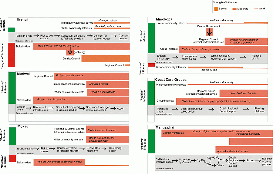
Figure 2. Summary of the influences driving what is perceived to
be negative and positive environmental outcomes at the six case study locations.
[Note: The thickness of the horizontal line is an approximation of the relative
strength of influence of the different groups involved in the process. The
length of the vertical bar on the lefthand column of the diagram shows the
relative sum of the influences driving the situation towards a positive or
negative environmental outcome. Time runs from left to right in the diagram
to show the points at which different influences come into play.]
Figure 3 illustrates the key role-players involved in negotiating environmental outcomes in the above case studies (depicted in the large oval), including community members, regulators and technical experts.
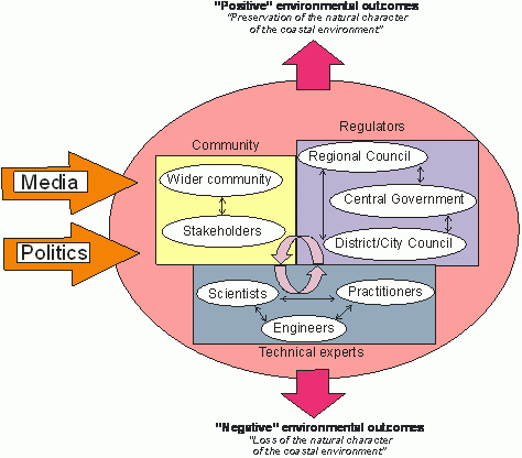
Figure 3. Key role-players involved in public decision-making to manage coastal erosion.
The media and political climate (or national level politics) tend have a more diffuse impact on the public decision making process rather than being active participants; unless they are being influenced by a local lobby group. However, once a consent application is in progress for a Restricted Coastal Activity the Central Government enters the debate (as a regulator) because of the role of the Minister of Conservation as the final decision maker. The community consists of stakeholders (with specific interests) and the wider community. After an erosion event, stakeholder groups tended to form, consisting of members of the community whose interests are imperilled by erosion (including permanent residents in beachfront properties, holiday home owners, agencies responsible for public infrastructure and operators of businesses dependent on a beachfront location). Such groups typically seek to protect their vested interests in their seafront location against the actual or perceived threat of erosion or a perceived failure of Local Authorities to address their concerns. Stakeholder groups in the above case studies were numerous and held diverse and potentially conflicting perspectives. There was almost always a group of beachfront property owners who wished to ‘hold the line’ with a hard engineering structure, usually a rock revetment. Stakeholder groups tended to strongly focus on protecting their interests, and either lobby local or central government (e.g., Urenui) or take direct action themselves (e.g., Mangawhai and Marokopa). The interests present within the wider community either at local, regional, or national level may or may not be represented by one of the stakeholder groups. In general, the wider community often favours a solution which protects public access or amenity values and may conflict with stakeholder group interests that are more narrowly focused on threats to particular properties or investments. However, stakeholder groups brought together by local government with a specific purpose (i.e., consultation) or facilitated during the early stages of decision making by a representative of a local authority (e.g., Muriwai, Mokau and many Coast Care groups) tend to be more inclusive and representative of wider community interests.
The regulators consist of those agencies with a statutory management responsibility (under the RMA and other relevant legislation) within the coastal environment, typically regional and district councils and the Department of Conservation. Each regulator, although subject to and responsible for ensuring the implementation of the laws of the land, may be responsible for particular statutes, and have different mandates, viewpoints, approaches and often prefer different solutions. This is quite typical of resource management in New Zealand because of the diversity of legal and policy imperatives and devolution to regional and district authorities to develop locally appropriate solutions (Gregory, 2008). Prevailing legislation and practice compels public consultation about resource management issues and hence resolution of coastal erosion problems will be subject to some consultative process, and potentially to a negotiated outcome. But as some the case studies illustrate, there is considerable variability in the extent to which prevailing consultative processes are inclusive and result in meaningful resolution of contending interests.
Technical experts include a mix of scientists, practitioners and engineers. This group may hold quite different professional perspectives about how to manage an erosion event. These views are probably linked to professional training, ‘current practice’ and personal preference about whether or not hard or soft engineering options are appropriate and how individual practitioners manage scientific uncertainty.
The relationships and interactions between, and within, the community, regulators and technical experts, and the extent to which contending interests can be satisfactorily resolved, shapes to a large extent the outcomes of efforts to address coastal erosion hazards. Although the context of each case study is different, a number of common themes emerge which determined the environmental outcome (see Figure 4).
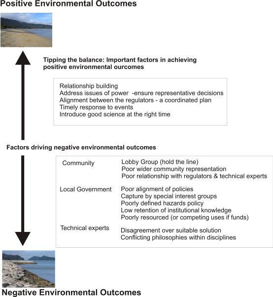
Figure 4. Key factors driving positive versus negative environmental outcomes.
Factors which give rise to Positive Environmental Outcomes
Overall the key drivers of whether or not positive or negative environmental outcomes were achieved are a function of relationship building; power balance and the representativeness of decisions; alignment between regulators; responding to events in a timely manner; and the role of good science.
Relationship building
The relationships between those involved in coastal hazard management are particularly important in shaping outcomes. Situations where co-operative relationships have developed between communities, local authorities and technical experts seem more likely to encourage positive environmental outcomes. Few relationships begin as being co-operative. The initial response from the community to a threat to private property, community assets or a popular beach is to ask “When is the council going to fix this?” In several of the case studies, local communities (e.g., Mangawhai) or individuals (e.g., Mokau, Marokopa) act on their own to solve erosion issues in the absence of advice from local authorities or technical experts. Concern about independent action is threefold: Firstly, it may favour one set of interests and values at the cost of others (e.g., Mokau). Secondly, it may be an ineffective or inappropriate action for that particular physical coastal environment (e.g., Mokau, Mangawhai). Thirdly, independent action is generally not permitted under the RMA (e.g., Mokau, Mangawhai). Independent action seems more likely if those concerned have difficult relationships with local authorities due to current or past issues (e.g., Mangawhai, Mokau). It is important to note that at Mangawhai and Marokopa the relationships have improved over time, but arguably due to efforts by the local authorities and technical specialists to engage with the community and work through the issues. In the Muriwai situation, and for the various Bay of Plenty Coast Care groups, local authorities and technical specialists were involved with the community from the very outset. By engaging with the community and working with them to establish a course of action meant that independent action and / or poor representation of the wider community interests was reduced and it was more likely that positive environmental outcomes would be achieved. This experience is consistent with the communicative planning literature which indicates that more appropriate solutions are generated through engagement with communities (see e.g., Healey, 1992; 1998). This task of building relationships usually falls to local authorities who need to work hard to build relationships with affected communities through effective (jargon free) communication, supporting community learning, transparency of process and honesty about the limits imposed by policy and plans, and managing expectations about the implications and feasibility of alternative solutions (Note: to give effect to these actions may require significant capacity building in some local authorities). It is important to maintain these relationships as negotiated solutions are implemented because groups like those at Mangawhai and Marokopa having succeeded in one area, move on to address other local issues. If the group does move on to other issues, a good working relationship with local authorities will help avoid revisiting earlier problems.
Addressing issues of power and ensuring representative decisions
Forester (1989) suggests that to ignore the power dimension of social interaction undermines and even precludes planning outcomes that serve public interests. As coastal property represents a significant financial investment, beachfront property owners typically push for coastline armouring, potentially at the expense of other interests associated with the coastal environment. In many cases, it falls to local authorities to include wider community interests into the process, or represent these interests themselves. A failure to do this will favour private over public interests.
In the above case studies, negative environmental outcomes appeared to be more common when communities affected by coastal erosion had lobby groups (community initiated groups which promote narrowly defined interests rather than wider community interests through interactions with local authorities and the media), and where there was limited wider community representation. In many cases, the loudest voice in a debate about what to do about coastal erosion was a lobby group of beachfront property owners or land users who had a strong interest in ‘holding the line.’ Often such groups claimed to legitimately represent the wider community (e.g., Urenui). Their influence can be considerable, particularly if they are articulate, well resourced and politically well connected. Powerful lobby groups were often skilled with their use of language to construct the problem. For example, the case for an extension to the rock wall at Urenui appeared in the media phrased as ‘urgent’, ‘necessary’ and a ‘failure’ if the council were to delay any further (West, 2005) - all strong emotive terms applied to emphasise their desired outcome and suggest irresponsibility of the council if other solutions were considered. The wall has subsequently been extended. In some cases, groups or individuals may be willing to act without consultation (e.g., Mangawhai, Mokau and Marokopa) and potentially at the expense of other parties. Cooper & McKenna (2008) point out that local communities may sympathise with those at risk of losing their house (or valued asset) to coastal erosion. However, beachfront property owners are not the only ones who stand to lose something. If participants involved in the negotiation of a solution to coastal erosion represent only one interest or a limited range of interests then, the final outcome will not be representative of community interests (Stephan, 2005). In addition, because of the intensity and emotive nature of disputes about how to manage coastal erosion at the local level, wider regional and national interests may be ignored. This is especially relevant in New Zealand because significant income is derived from tourism and product differentiation dependent on a “clean green” environmental image and unspoilt landscape (Ministry for the Environment, 2001). Moreover, there is public demand and a legal imperative to maintain the natural character of the New Zealand coast.
Alignment between the regulators – a co-ordinated plan
Gregory (2008) points out that local authorities want increased direction from central government about dealing with coastal management issues and, at the same time, to be left to make local decisions themselves. The revised NZCPS (see Department of Conservation Policy Group, 2008) ought to help resolve these tensions, although it is not clear to what extent it will achieve this goal. Although the NZCPS informs a hierarchy of plans (Regional Coastal Plans and District plans) and policy statements (Regional Coastal Policy Statement), which must not be inconsistent with each other, differences arise with interpretation and implementation in practice. This may be attributable to the differences in weighting given to economic, social and environmental and cultural factors in the resource consent process. Decision makers may privilege any one of these factors depending on their own personal perspective (Dobson, 2003) and interpretation of the situation at hand. In coastal decisions it is not uncommon for economic interests and private property rights to ranked above environmental or wider social concerns (Peart, 2008). This is especially true when strong economic interests or powerful lobby groups representing specific interests are present. As the RMA is an effects based piece of legislation each consent application is considered independently which creates difficulties in assessing the cumulative impacts of coastal sub-division or coastline protection works. Moreover, as each outcome can be negotiated (with guidance from council plan and policy and case law) there is the potential for private interests to continually supersede the interests of the wider community and New Zealanders as a whole. What is absent at the national or regional level is more specific direction in policy statements and plans as to which beaches will be developed and which will not. This guidance will provide a more coordinated approach to coastal development, minimise ad-hoc responses to individual consent applications for structures on the coast and provide what New Zealanders profess to want and value (Becker et al., 2007; Dahm, 2003).
Respond to events in a timely manner
Coastal communities have a low perception of risk to coastal erosion events unless local property or beaches are under threat. After an erosive storm event, the community may have a very different, more imminent perspective on the threat of coastal erosion to that held by a local authority or technical expert. Communities typically are unfamiliar with the technical aspects of erosion events. Conveyance of risk is challenging because of the scientific uncertainty involved and the need for sufficient technical information to demonstrate whether or not a particular erosion event is part of a short-term trend (months and years) of cyclic shoreline advance and retreat which may ‘cure itself’ without the need for intervention. In such cases the risk is less than a particular event may indicate and properties may be useable for several more decades. A failure to respond appropriately may be considered abandonment of the community by the local authority and perhaps result in action by individuals to protect their investment (i.e., Mangawhai, Mokau). In most cases, the action is illegal (i.e., an un-consented activity in the coastal marine area) and ineffective from a scientific perspective. At Urenui, council inaction led to resentment festering within the community and when the council did act to negotiate a solution there was already a considerable amount of frustration and stakeholders had adopted entrenched positions. Council requirements to follow a particular process (as outlined by their policies and plans) and balance the demands of all constituents in the district or region take time and may be poorly recognised or mis-interpreted as delaying tactics or disinterest. These institutional processes may take time, but acting early to engage with an affected community and overcome community misconceptions about risks and council processes and priorities are key aspects in achieving positive environmental outcomes which retain natural character.
The role of good science
‘Good science’ can play an important role in managing coastal erosion because it can explain the physical context, provide estimates of risk and outline management options. However, it should not dominate the decision-making process. Rather scientific understanding needs to be integrated with local and traditional knowledge to help inform participants about the situation and trade-offs and likely outcomes of different solutions. The key is to include scientific and technical information in an appropriate manner and at the right time in the debate, a task which usually falls to specialists within local authorities.
Retention of technical knowledge in terms of staff skills and records of past events, processes and decisions is essential to informing the debate and good management decisions. A loss of institutional knowledge of coastal hazard issues at Mokau occurred within local authorities and affected communities, primarily because erosion events were decades apart. Staff turnover and scattered storage of relevant documentation was not conducive to maintaining community relationships and knowledge about historical erosion events and, importantly, the lessons learnt from previously negotiated solutions. In the community, newcomers were not aware of the long term erosion trends nor details of past community decisions. This presents two key problems: First, new staff require time to ‘get up to speed’ on the issues and history and develop trust with the community, which may hinder or slow the resolution process. Second, a new cycle of property ownership in hazard prone areas can lead to a (potentially expensive) recycling of issues and consultation. This may be perfectly reasonable should the community as a whole wish to renegotiate. But it could be more problematic if it is simply a few new stakeholders who are taking the chance to challenge an earlier sound decision.
In contrast a more structured approach was adopted at Muriwai. Here technical information on coastal processes was assembled by council and reconciled with the community’s knowledge about local processes and various options to address the issues through public meetings and wider consultation. Decisions were then formalised in a management plan incorporating coastal hazard setbacks which allowed newcomers to see what was agreed upon and how it will be implemented. With a more structured approach it is important that bureaucratic processes do not stifle the exchange of dialogue between the various parties and inhibit relationships and the consultative process.
Well designed hazard zones and development setbacks provide an important opportunity for science to inform coastal management. While there is still uncertainty because of the lack of data on coastal processes and debate amongst experts as to the best methods for designing coastal setbacks and hazard zones and how to apply them, they provide valuable quantitative information to inform deliberations. Hazard zones incorporate technical information into maps illustrating what parts of the community are at risk from particular events and provide guidance as to where development is best located. The maps form the focus for discussions between the community and the local authority about future management options so that trade-offs and reconciliation of competing interests can begin. All new subdivisions are required to have setbacks which accommodate current and future risks by providing a buffer space for the naturally occurring movements of the shoreline in response to variability and change in coastal processes, and space for preservation of natural character, biodiversity and public access to our coastal margins. Where setbacks and hazard zones are not in place coastal erosion issues are dealt with in a more reactionary ad-hoc manner. Ad-hoc responses are more likely to lead to negative environmental outcomes as lobby groups can have more impact, and issues have a greater chance of being assessed without considering cumulative long term impacts or interests of the wider community.
The lack of good science input is an issue faced by councils with a small rating base. Due to the small size of their operations, meagre in-house technical resources, and limited access to information, council resource officers are forced to be “Jack of all trades” with many issues to cover on limited funds and time. How to deal with coastal erosion presents councils with a significant challenge under these circumstances.
Disputes over how to address coastal erosion are frequently emotional and contentious because of the values and interests associated with the coastal environment and the distribution of costs and benefits generated by different management strategies. This paper has argued that environmental outcomes following a coastal erosion event which threatens private property, community assets or a popular beach is influenced by who is involved in negotiating solutions and how contending interests are reconciled, how resource management agencies behave and the nature of the physical coastal environment. Positive environmental outcomes, which result in retaining the natural character of the coast, are more likely when co-operative relationships are developed between local authorities, technical experts and communities through facilitated discussion, learning, information exchange and resolution of conflicting values and interests. Independent action by individuals or community groups appears to be more common in the absence of such relationships or when the local authorities’ response is not considered timely. One of the most important considerations is to ensure all interests are represented in the decision-making process and that power differences are addressed to avoid capture of the process by a group with narrow interests that conflict with community interests. This may mean incorporating interests beyond the immediately impacted community.
From a local authority perspective, a clear understanding of the scientific and historical information relevant to a given coastal erosion event provides a good basis for beginning negotiations with stakeholders over potential options. Care needs to be taken to ensure the science is introduced to the community at the right time in an appropriate manner to ensure open discussion about the impacts of alternative options.
One of the dangers in addressing coastal erosion events is a focus on short term stakeholder interests at the local community level rather than longer term regional and national interests. A response to individual community concerns, if not managed carefully, could lead to a highly modified coastal environment. It is imperative for the revised NZCPS to provide national guidance on how to manage coastal erosion.
This work was funded by the New Zealand Foundation for Research Science and Technology under subcontract to GNS Science in the programme Geological Hazards and Society (Contract C05X0402), Objective 1, Land use planning for reduction and recovery. We are very grateful to the individuals and representatives of community groups and Regional Council officers who provided much useful material and interesting debate on their issues. We thank Julia Becker, Wendy Saunders and Janine Kerr of GNS Science for useful discussions. Darcel Rickard of NIWA assisted with transcribing interviews.
Becker, J. S., Stewart, C., Coomer, M., Hume, T., Blackett, P., & Davies, A. (2007). Managing our coast: The tabulated results of two community surveys undetaken at Tairua and Waihi Beach (GNS Science Report). Wellington: GNS Science.
Bin, O., & Kruse, J. B. (2006). Real Estate Market Response to Coastal Flood Hazards. Natural Hazards Review. 7(4), 137-144.
Blackett, P., & Hume, T. (2006). Community involvement in coastal hazard mitigation: An initial scoping of process and pitfalls (NIWA Client Report, prepared for GNS Science No. Ham2006-083 ). Hamilton: NIWA.
Burnley, I. H., & Murphy, P. A. (2004). Sea Change: Movement from metropolitan to Arcadian Australia. (Vol. 19). Sydney: University of New South Wales Press.
Cheyne, C., & Freeman, C. (2006). A rising tide lifts all boats? A preliminary investigation into the impact of rising New Zealand coastal property prices on small communities. New Zealand Journal of Social Sciences. 1, 105-124.
Cooper, J. A. G., & McKenna, J. (2008). Social justice in coastal erosion management: The temporal and spatial dimensions. Geoforum. 39(1), 294-306.
Dahm, C. (2003). Beach User Values and Perceptions of Coastal Erosion (Environment Waikato Technical Report No. 2003/03). Hamilton: Environment Waikato.
Dahm, J. (2000). Natural Character: Concept Development in New Zealand Planning Law and Policy. Hamilton: Environment Waikato.
Department of Conservation. (1994). New Zealand Coastal Policy Statement. Wellington: Department of Conservation.
Department of Conservation Policy Group. (2008). Proposed New Zealand coastal policy statement 2008. Wellington: Department of Conservation.
Dobson, A. (2003). Justice and the Environment: Conceptions of environmental sustainability and dimensions of social justice. Oxford Oxford University press.
Environment Bay of Plenty. (2009). Coast Care Restoration. Retrieved 24th July 2009, http://www.envbop.govt.nz/Sustainable-Communities/Coast-Care-Restoration.aspx
Flood, S., Cocklin, C., & Parnell, K. (1993). Coastal resources management conflicts and community action at Mangawhai, New Zealand. Coastal Management. 21(2), 91-111.
Forester, J. (1989). Planning in the face of power. Berkeley: University of California Press.
Goff, J. N., S. & Rouse, H.L. (eds). (2003). The New Zealand Coast. Te Tai Aotearoa, New Zealand. Palmerston North.: Dunmore Press.
Gregory, D. (2008). 'There is a tide': An examination of the evolution of New Zealand Coastal Policy Statements. New Zealand Geographer. 64(2), 144-153.
Healey, P. (1992). Planning through debate: the communicative turn in the planning debate. Town Planning Review. 63(2), 143-162.
Healey, P. (1998). Building institutional capacity through collaborative approaches to urban planning. Environment and Planning A. 30, 1531-1546.
Healy, T. R., & Kirk, R. M. (1982). Coasts. In J. M. Soons & M. J. Selby (Eds.), Landforms of New Zealand. Auckland: Longman Paul, pp. 81-104.
Hume, T. M., & Herdendorf, C. E. (1988). A geomorphic classification of estuaries and its application to coastal resource management - A New Zealand example Journal of Ocean and Shoreline Management. 11, 249-274.
Kay, R., & Alder, J. (2005). Coastal planning and management. Oxon: Taylor & Francis.
Kitchin, R., & Tate, N. J. (2000). Conducting research into human geography: Theory, methodology and practice. Harlow, England: Prentice Hall.
Klein, R. J. T., Nicholls, R. J., Ragoonaden, S., Capobianco, M., Aston, J., & Buckley, E. N. (2001). Technological Options for Adaptation to Climate Change in Coastal Zones. Journal of Coastal Research. 17(3), 531-543.
Ministry for the Environment. (2001). Valuing New Zealand's clean green image. Wellington: Ministry for the Environment.
Nicholls, R. J., Wong, P. P., Burkett, V., Codignotto, J., Hay, J., McLean, R., et al. (2007). Coastal systems and low-lying areas. In M. L. Parry, O. F. Canziani, J. P. Palutikof, P. J. v. d. Linden & C. E. Hanson (Eds.), Climate Change 2007: Impacts, Adaptation and Vulnerability Contribution of Working Group II to the Fourth Assessment Report of the Intergovernmental Panel on Climate Change. Cambridge: Cambridge University Press, pp. 315-356.
Peart, R. (2008). Time to get serious about our coastline. New Zealand Herald. 29 January, 2008.
Pilkey, O., & Hume, T. (2001). The shoreline erosion problem: lessons from the past NIWA Water & Atmosphere. 9(2), 22-23.
Ricketts, P. J. (1986). National policy and management responses to the hazard of coastal erosion in Britain and the United States. Applied Geography. 6(3), 197-221.
Stephan, M. (2005). Democracy in Our Backyards: A Study of Community Involvement in Administrative Decision Environment and Behaviour. 37(5), 662-682.
Stewart, C., Leonard, G., Johnston, D., & Hume, T. (2005). The 2003 National Coastal Community Survey: Results for Waikato communities. Wellington: Institute of Geological & Nuclear Sciences Science.
Turbott, C., & Stewart, A. (2006). Managed retreat from coastal hazards: options for implementation. Hamilton: Environment Waikato.
West, R. (2005). Beach users group makes plea for longer rock wall at Urenui. Taranaki Daily news. 17 May 2005.
Wilson , V., & Salter, J. (2003). A Guide to the Local Government Act 2002. Wellington: Thomson DSL Publishing.
| Comments to Trauma.Webmaster@massey.ac.nz Massey University, New Zealand URL: http://trauma.massey.ac.nz/ |
Disclaimer
Last changed
10 February, 2010
|