 |
Urban-Forest
Interfaces:
|
| |
Urban-Forest
Interfaces:
|
Urban-Forest Interfaces:
A Favourable Stage for the Incidence
and Development of Forest Fires in Portugal
Over the last few years, Portugal has been in the international news spotlight due to the forest fires which, in a greater or lesser degree of severity, afflict the country almost every summer. However, it was especially in 2003 and 2005 that the country received the most media attention, since the forest fires were very fierce indeed in those years.
While the fires in 2003 could to some extent be largely attributed to an abnormal incidence of dry thunderstorms, especially on the 1st and 2nd of August, the ease with which the fires spread in 2005 was mainly the result of the extremely severe drought which Portugal suffered that year. But these factors alone cannot explain the ferocity of the situations experienced in those two years.
In fact, many of these fires could not only have been avoided, but their spread could have been impeded, or even halted, if some simple steps had been implemented - steps which would have prevented the danger from threatening many houses, warehouses, agricultural facilities and other buildings located on the urban-forest interfaces or even within the cities themselves.
Urban-Forest Interfaces:
A Favourable Stage for the Incidence
and Development of Forest Fires in Portugal
Though the purpose of this paper is not to carry out a detailed analysis of the situations which allowed the abnormal development of large forest fires in Portugal in 2003 and 2005, the main contributing aspects have to be mentioned. This is to demonstrate that, contrary to what is often heard and is still affirmed, the resolution of the problem essentially requires prevention, through the specific implementation of some straightforward steps designed to achieve the better planning and management of forest areas (Beringer, 2000; Granger et al., 2000; Caballero et al., 2007).
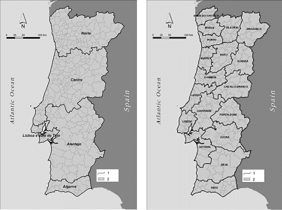
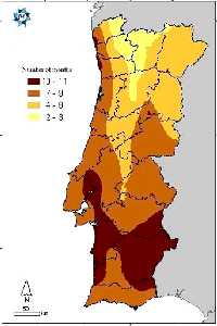
The analysis will mostly focus on districts in the North and Centre of Portugal (Fig.1) where, interestingly, there were hardly any major forest fires in 2003 and yet, in 2005, these were the areas where the most serious and difficult incidents occurred.
The methodology adopted for this study relied to a great extent on direct observation, both of the situations which contributed to such a significant number of fires and of the circumstances which enabled the fires to spread, with considerable damage to forestry resources as well as significant costs required by the respective fire fighting efforts.
Official statistics on forest fires issued by the Directorate General of Forestry Resources (DGRF) and by the National Firemen and Civil Protection Service (SNBPC) were also consulted, as well as satellite images and other information available on the Internet and other media.
The aim was to understand why the Northern and Central coastal districts (Viana do Castelo, Braga, Porto, Aveiro, Coimbra and Leiria), as well as those further inland (Vila Real and Viseu) (Fig. 1) behaved differently, in terms of the number of forest fires and extent of burnt areas, in the critical years of 2003 and 2005 when at first nothing appeared to hint at this.
In order to help us understand why such a large number of fires occurred, and why the average size of areas burned was so high, we will first establish their historical context by giving an overview of the evolution of forest fires in Portugal.
The particularly problematic years of 2003 and 2005 will then be examined, and the specific situations of urban-forest interfaces will be analysed, illustrating these with some of the situations experienced.
The large number of forest fire incidents in mainland Portugal is normally linked to human causes (Lourenço, 2006a), which may occasionally be deliberate but most cases are due to carelessness (Coutinho, 2006).
But hardly any forest fires are investigated as a rule – on average only 3.77% of fires reported were investigated between 1993 and 2003, and the cause was established in only 2.33%, leaving 1.44% with their origin unknown (Gonçalves, 2006, 268). And this situation has worsened in the years since then (Fig. 2).
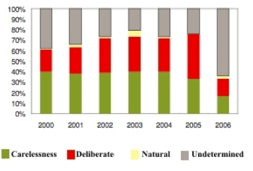
Fig. 2 - Causes of start of forest fires investigated, from 2000 to 2006.
The poor representativeness of the sample and, above all, the fact that investigation of the causes does not follow any statistical criteria of quality control, since there are local differences in data collection criteria (Gonçalves, 2006) and the sampling is not random, with all fires suspected of being deliberately started being investigated, mean that the figures thus obtained cannot be extrapolated to the country as a whole.
In addition, the figures for causes of human origin vary according to region, with arson being predominant in the coastal areas of central and northern Portugal, negligent use of fire in the interior regions, also in the centre and north, and accidental causes in the south (DGRF, 2006, 13).
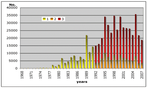
These stem from attitudes and behaviours which, although they have long been identified (See footnote 1) , require urgent change (See footnote 2) in order to be able to reverse the trend plotted by the number of fires over the last few years, a reversal which finally seems to be starting in the early years of this 21st century, if we accept that 2005 was an anomaly (Fig. 3).
The steady rise in both the number of fires and the size of the areas burnt observed since the mid 1970s are the outcome of a series of changes affecting the Portuguese rural world. These were a result of the rural exodus which began in the 1950s, driven by the search for better living conditions. People went either to the city of Lisbon, as a result of the growing industrialisation of the Setúbal peninsula and the ensuing labour requirements (Cravidão, 1989), or abroad, where the favoured destination was France, but subsequently included other countries, mainly in Central Europe.
The revolution of the 25th of April 1974 played a decisive role in accelerating these transformations, by introducing radical changes in the structure of Portuguese society, both at the social level and at the economic and cultural levels, not to mention the impact on the age structure of rural communities.
Furthermore, the greater access to new energy forms, particularly gas and electricity, meant that they were used more and so the need for wood inevitably dwindled, and it then began to accumulate in the forests.
Equally, the reduction in livestock herds, especially small ruminants (goats and sheep), facilitated the decline in the consumption of brushwood, which used to be used for feeding the animals and for their bedding, further adding to the accumulation of biomass in the forest. At the same time, new agricultural practices were being introduced, which resulted in a decline in the consumption of organic manure and an increase in the use of chemical fertilisers. These factors also implied a fall in the use of brushwood, with a consequent rise in the combustible residue which remained unused in forests (Lourenço, 1992).
This situation tended to worsen, and many owners of tracts of forest abandoned them, faced with the increasing risk of fires. This led to poorer management of forests. All these facts together explain the rising number of fires and the greater extent of burned areas.
There was a sudden increase in the number of fires in 1981 (Fig. 3), and this is explained by the changes which had been introduced in the method used to compile the statistics. The progressive increase throughout the ‘90s was also partly due to greater rigour in the processing of statistical information.
Source of statistical data: DGRF
Fig. 3 – Evolution of the annual number of forest
fires in Mainland Portugal.
1 – no. of incidents, 2 – no. of fires ≥ 1 ha, 3 –
no. of fires < 1 ha
But 1995, 1998 and 2000, when the greatest number of fires were registered during that period were characterised by weather conditions which were particularly favourable to the outbreak of fire. Whilst this is important, it does not wholly explain the increase in the number of incidents. This is because, as already noted, fires are essentially caused by people. In 1991 for instance, when there were fewer fires than in 1989, the largest total area burned in a single year in the 20th century was recorded (Fig. 4). This was mainly due to the weather conditions.
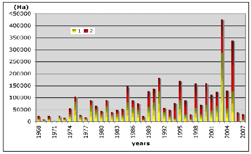
Source of statistical data: DGRF
Fig. 4 – Annual evolution of total area burnt
in Mainland Portugal.
1 – Burnt area in forest communities 2 – Burnt area in undergrowth.
So, although the extent of the area burned depended heavily on the weather conditions in each year, other equally important factors include the absence of land-use planning, the lack of adequate forest management and, on occasion, even a certain lack of effectiveness in operating fire fighting resources.
Therefore, the apparent success of controlling the extent of the area burned in 1977, 1988 and 1997 should be ascribed more to the weather conditions, which were not very favourable to the outbreak and propagation of forest fires, than to any other factor.
But the same is not true of the catastrophes associated with 2003 and 2005. As we will see, these events cannot be solely ascribed to the heat wave at the end of July and beginning of August 2003, nor to the lightning discharged by the dry thunderstorms on the 1st and 2nd of August 2003, nor the drought year of 2005. These two years, as the worst on record, certainly deserve a more detailed analysis.
There is no doubt that the weather conditions mentioned above were important, but they were not the only relevant factors. Ultimately, the blame lies with factors such as the neglected state of many of our woods and forests, and the lack of land-use planning and monitoring (Lourenço et al., 2006), or the poor coordination between the relief and rescue services, which were operating in large arenas, and the ineffectiveness of their performance.
The relief and rescue services’ failures were often due either to the lack of certified training or the use of inadequate equipment in many of those scenarios. These are just a few of the commonest and most frequently observed aspects (Lourenço, 2006a).
Even in the years considered to be bad in terms of weather, for being more favourable to forest fires, the factors did not always converge propitiously. This happened in the notorious year of 2003, in areas in the North and Centre of Portugal, which are traditionally badly affected by forest fires. In 2003, when there was a succession of days when weather conditions did not favour fire breaking out, there was a substantial reduction in the number of fires. This will have contributed to greater effectiveness in combating them and, at the same time, a certain degree of success in reducing the size of the area burned.
But further inland, particularly in the mid-Tejo region and the Algarve, where the levels of risk have traditionally been significantly lower, in 2003 there was some disparity between the existing firefighting resources and those that would have been desirable, given the degree of fire risk observed. This no doubt also contributed to the huge extent of burnt areas recorded (Fig. 5).
In fact, the first three days of August 2003 were exceptionally hot in most
of the country. Maximum temperatures were over 40ºC – the highest
temperature recorded was 47.2ºC, in Amareleja (interior south) –
and were coupled with high minimum temperatures, even at night, with temperatures
above 25°C in most of the country and even exceeding 30ºC in the
Portalegre, Proença-a-Nova and Caramulo (Central Portugal) weather stations.
It must also be pointed out that these extremely high maximum and minimum
air temperatures continued for a significant number of consecutive days. In
addition, relative air humidity was very low, particularly inland, where in
some places it was below 20%.
As a result of these and other circumstances, the outcome for 2003 could not have been worse, in terms of forest fires. Twelve of the 20 largest forest fires since records began occurred in this year, including 8 of the 10 largest fires ever seen in Portugal, resulting in an extensive burned area – the largest ever (Fig. 4 and Table 1).
Table 1 – Comparison of the forest fires from 2003 to 2006
| Years | 2003
|
2004
|
2005
|
2006
|
|---|---|---|---|---|
| No. of
firefighters killed during service |
4
|
2
|
12
|
9 |
| Burnt area
(ha) |
425 726
|
129 539
|
338 262
|
75 052
|
| Area of
the largest forest fire (ha) in the year |
41 079
|
25 717
|
19 433
|
5 690
|
| No. of
Forest Fires ≥ 10 000 ha |
8
|
1
|
3
|
0 |
| No. of
Forest Fires ≥ 1 ha |
5 290
|
4 805
|
8 089
|
3 410
|
| Total no.
of fires |
26 195
|
21 970
|
35 690
|
21 681
|
| Re-ignition |
913
|
942
|
1 143
|
469 |
These figures cannot be explained simply by weather-related arguments. In fact, in light of the risk indexes, the large burnt areas did not extend throughout the mainland. They were at first confined to the Centre-South and the Algarve, only later spreading to the Centre-North inland area. Now, a management approach more consistent with the risk index would have made it possible to use the resources available in the Central and Northern coastal regions, where there is better provision, moving them to the areas where and when they were needed the most.
2005 was another exceedingly difficult year, and one when forest fires received the most media coverage, because of both the large number of fires – the largest ever observed (Fig. 3) – and the size of the area burned – which was the second largest since records began (Fig. 4). But the weather conditions were different from 2003.
 |
 |
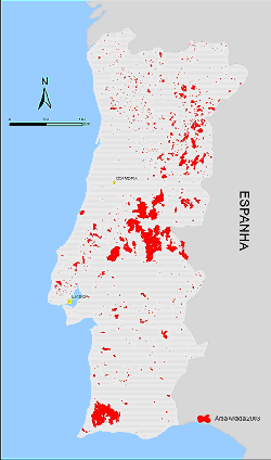
Source: DGRF, adapted. Fig. 5 – Area burned in mainland Portugal
in 2003. |
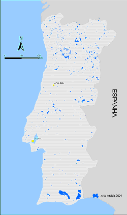
Source: DGRF, adapted. Fig. 6 – Area burned in mainland Portugal in 2004. |
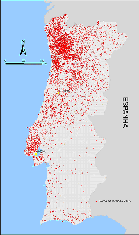
For this reason, the spatial distribution of the areas burnt in 2005 was different from the two previous years, 2003 (Fig. 5) and 2004 (Fig. 6). The more usual pattern was resumed, since the largest burnt areas were once again in the Centre and North (Fig. 6), and also because this was where the largest number of fires occurred, many of them close to urban centres (Fig. 8), a recurring situation. In fact, this is the reason behind the title of this article, and so we shall focus on the explanations for some of those situations.
Before this, however, it should be noted that this year also differed from 2003 and 2004 in terms of weather conditions, given that droughts were much more significant. Actually, from January to March 2005 the drought led to the outbreak of several fires, even though they did not involve a significant extent of burnt area.
 |
 |
 |
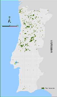
| Source: DGRF, adapted. Fig. 7 – Area burned in mainland Portugal in 2005. |
Source: DGRF, adapted Fig. 8 – Number of forest fires in mainland Portugal in 2005. |
Source: IM, adapted Fig. 9 – Spatial distribution of the number of consecutive months of severe and extreme meteorological drought in the 2004/2005 hydrological year |
Weather conditions then worsened once again and as a result several fires broke out in June, although the largest forest fires mainly occurred in July and August, as usual.
Now, while the high levels of areas burned in 2003 were apparently justified by the exceptional weather conditions (which was not strictly true (Lourenço, 2006b), given that the number of dry thunderstorms was only abnormally high on the 1st and 2nd of August), in 2005 the drought argument was the one most often used to explain the extent of the burnt areas, even though these areas did not coincide with the regions where the drought was most severe (Fig. 9). From this we may conclude that drought, although important, was not the main element justifying the extensive area burned in 2005.
In 2003, therefore, the areas mostly affected by major forest fires were largely in the south and the interior (north and centre), with the coastal districts in the north and centre being less affected. These latter areas suffered more in 2005, when abnormally large areas were burned, four to seven times more than the average for the previous 25 years. The number of events was also high, being generally double the average for the previous 25 years, but four times higher in Aveiro district.
The geographical distribution of the starting points of the forest fires registered in 2005 (Fig. 8) clearly shows that they were centred in the north, although there was another fairly significant belt around the Lisbon metropolitan region, thus corresponding to the most densely populated areas, a relationship which also hints at the essentially human origin of the fires.
In 2005, in fact, the district of Porto – which traditionally has the largest number of fires (Table 2) – registered almost twice as many as those observed in the coastal districts which border it, Braga and Aveiro (respectively immediately to the north and south), and Viseu and Vila Real, which border it inland, respectively to the south and east.
This distribution suggests that the high number of incidents is related to situations which are specific to that geographical context. In many cases it can also be related to the dispersion of housing in the middle of the forested areas, together with the existence of small entrepreneurial units, of a family industry type. There are other situations where a certain type of agricultural and forestry activity traditionally uses fire to eliminate residues and debris from farming operations.
However, contrary to the norm, in 2005 the Porto district recorded an abnormally large extent of burnt area (Fig. 10), five times greater than the average for the previous 25 years (Table 3). This has motivated us to try to understand the reasons, apart from the drought conditions already mentioned, which are likely to have contributed towards such a significant number of fires. A number that is interestingly very similar to that for 2003, but where, on the other hand, only 1/3 of the area consumed by the fires in 2005 was burnt.
Source: DGRF, adapted.
Table 2 – Number of forest fires in mainland Portugal,
by district,
in 2005 and averages for the previous 25 years
| District * | 2003 | 2005 | Average of the 25 years prior to 2005 |
||
|---|---|---|---|---|---|
| Total | ≥ 1,000 ha | Total | ≥ 1,000 ha | ||
| Porto | 7 720
|
0
|
7 534
|
1
|
3 733
|
| Braga | 4 376
|
0
|
4 762
|
0
|
2 195
|
| Aveiro | 1 581
|
0
|
4 479
|
4
|
1 118
|
| Viseu | 1 976
|
0
|
3 859
|
5
|
1 720
|
| Vila Real | 1 342
|
0
|
2 505
|
6
|
1 177
|
| Lisboa | 2 399
|
1
|
2 451
|
0
|
1 288
|
| Viana do Castelo | 911
|
0
|
2 426
|
5
|
1 037
|
| Leiria | 845
|
3
|
1 406
|
9
|
586
|
| Guarda | 1 158
|
13
|
1 310
|
6
|
1 166
|
| Santarém | 1 007
|
8
|
1 086
|
5
|
584
|
| Coimbra | 507
|
1
|
1 016
|
3
|
633
|
| Bragança | 635
|
4
|
814
|
2
|
554
|
| Castelo Branco | 593
|
8
|
764
|
2
|
584
|
| Setúbal | 659
|
4
|
625
|
0
|
409
|
| Faro | 203
|
2
|
341
|
0
|
261
|
| Beja | 113
|
0
|
114
|
0
|
582
|
| Portalegre | 102
|
6
|
104
|
0
|
90
|
| Évora | 68
|
4
|
51
|
0
|
66
|
| Total | 26 195
|
54
|
35 647
|
48
|
17 281
|
Table 3 – Burnt area (ha) in mainland Portugal, by district, in 2005 and averages for the previous 25 years
| District * | 2003 | 2005 | Average of the 25 years prior to 2005 |
|---|---|---|---|
| Coimbra | 2 902
|
50 603
|
8 930
|
| Viseu | 6 188
|
38 075
|
10 746
|
| Vila Real | 4 976
|
36 990
|
8 381
|
| Santarém | 66 929
|
28 749
|
8 355
|
| Viana do Castelo | 1 494
|
27 068
|
4 716
|
| Leiria | 9 568
|
25 675
|
3 878
|
| Guarda | 45 494
|
23 957
|
19 381
|
| Porto | 7 945
|
22 297
|
4 352
|
| Aveiro | 799
|
22 012
|
3 037
|
| Castelo Branco | 90 253
|
19 794
|
12 190
|
| Braga | 3 683
|
12 354
|
3 418
|
| Bragança | 15 088
|
11 741
|
5 697
|
| Lisboa | 9 738
|
2 076
|
1 785
|
| Portalegre | 69 348
|
1 811
|
3 499
|
| Faro | 57 178
|
1 666
|
6 050
|
| Beja | 15 381
|
1 606
|
1 958
|
| Évora | 9 777
|
1 373
|
1 049
|
| Setúbal | 8 054
|
1 038
|
910
|
| Total | 425 726
|
329 084
|
108 321
|
We also sought to identify what procedures would be needed to deal with such a large number of forest fires. Procedures either did not exist or were ineffective, in which case they must be rectified. Fires could thus spread relatively easily, and it was not possible to prevent either significant damage to the forests or the high costs of the firefighting efforts.
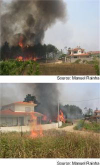
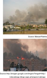
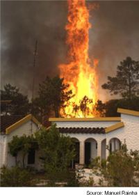
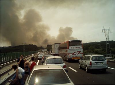
The most critical situation in the Porto district occurred between the 4th and 12th of July, when a significant number of forest fires was recorded, particularly on the outskirts of the city, in the municipalities of Valongo, Paredes and Gondomar. The people in the affected areas (Photo 1) became very concerned because of the threat the fires posed to buildings (Photo 2), and because of the disruption to normal activities, particularly since the fires affected the road (Photo 3) and rail networks.
 |
 |
 |
| Photo 2 A - Detail of forest fire within the urban perimeter of Gondomar (July 08, 2005) | Photo 2 B - Detail of forest fire within the urban perimeter of Valongo (August 20, 2005) | Photo 2 C - Detail of forest fire within the urban perimeter of Caldas da Rainha |
[Source: http://images.google.com/imgres?imgurl=http://orelhadoano.no.sapo.pt/incendio.jpg& imgrefurl=http://orelhadoano.blogspot.com/2005_08_01_archive.html&h=768&w=1024&sz=333&hl]
Photo 3 - Traffic halted on the Porto-Lisbon motorway, because of the forest fire in 2005.
In these circumstances the need to be able to mobilise better resources in order to control problem was obvious. On the 8th of July 2005 the municipalities of Paredes and Gondomar activated their Municipal Emergency Plans, which resulted in an increase in firefighting resources, especially the use of heavy machinery and the organisation of logistical support.
Of the fires which were burning simultaneously, the largest, in terms of total area burnt and resources engaged, began at dawn of the 4th of July, in Santa Comba, in the municipality of Paredes. After it was thought to have been put out, it re-ignited during the morning of the same day and was driven by strong winds towards the parish of Melres, in the municipality of Gondomar (Fig. 10). It was thought to have been extinguished on several occasions in the following days, but it always rekindled. It was finally put out on the 11th of July.
It covered about 1 550 hectares of forest, mainly on the periphery of urban areas or within the urban perimeter itself. This was only possible because these areas had almost all been developed with next to no planning. Lack of planning poses additional problems when it comes to protecting the forest against fires at these urban-forest interfaces. Huge amounts of resources have to be mobilised to protect inhabited areas, works sites, factories, petrol stations and other infrastructures located on the outskirts of or within the areas hit by the fire This was because no preventive/protective measures had been taken i.e. by clearing surrounding belts of vegetation.
Another forest fire in the same period which required the mobilisation
of considerable resources, on land and in the air was the fire which surrounded
the Campidouro Campsite, also in the municipality of Gondomar, on the 10th
of July 2005. Even though, fortunately, it did not cause any damage, it was
another fire which necessitated the protection of hundreds of people on the
campsite. Although it was surrounded by forest, this campsite inexplicably had
no kind of protective belt against forest fires (Photo 4). And the forest fire
itself had to be tackled, too.
Source: Manuel Rainha
Source: Manuel Rainha.
Photo 4 - Campidouro campsite, in the heart of woodland, without any outer fire break.
The same sources remarked that people using the amenity had little awareness of personal safety and so they also had no idea how to respond appropriately to deal with an emergency of this nature, especially in terms of preventing and reducing the risk of accidents.
But in spite of the many unforeseen dangers which can emerge at any time in this type of fire, which develops at the urban-forest interface, no fatal accidents were recorded. Equally there was no significant damage to houses or other property, which clearly reveals the effort and dedication of the firefighters and locals who tried to fight the flames.
However, much of this effort, which was sometimes even in vain, would probably have been largely unnecessary had some of the problems which were becoming chronic been solved. There seems to be no plausible explanation for this failure.
It was Coimbra district, however, which recorded the largest burnt area in 2005 (Fig. 11 and Table 3), and it was also one of the districts which saw the flames penetrate its urban perimeter.
Although it was not a new situation, it was quite out of the ordinary, to the extent that projected bits of red hot eucalyptus (Eucalyptus globulus) leaves and bark caused many new fires, enabling the main fire to progress very rapidly without the firefighters having the chance to react quickly enough to halt its explosive progression.
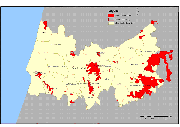
Fig. 11 - Burnt areas in 2005, in municipalities in Coimbra district.
This is what happened. On the 20th of August, there was a fire in the neighbouring municipality of Vila Nova de Poiares, which lasted into the following day (Fig. 12).
Now, on the afternoon of the 21st of August, 57 forest fires were raging simultaneously in Portugal, and 51 of these were yet to be contained. Many of them had started days before, and they were occupying a total of 3 400 firefighters, 37 aircraft and 25 military platoons, backed up by 4 bulldozers in firefighting, damping-down and post-fire surveillance missions.
Three of these were very serious fires in the Coimbra district, all of which had started earlier. They raged across the municipalities of Pampilhosa da Serra, where 19 500 hectares were burnt, Soure, where 1 850 hectares were burnt, and Vila Nova de Poiares (Fig. 11). This is the one that later spread to the neighbouring municipalities of Coimbra, Miranda do Corvo and Penela, having devoured 12 147 hectares of woodland (Fig. 12).
At 7 o’clock on the afternoon of the 21st of August the fire was already approaching the western edge of the municipality of Vila Nova de Poiares, heading towards Coimbra, but it was still to the southeast of the river Mondego. It crossed the Mondego valley at the end of that day and the beginning of the next, spread by airborne sparks of pine-needles, and red hot eucalyptus leaves and bark.
The fire broke into the municipality of Coimbra at the end of the afternoon on the 21st, which was a Sunday – the ultimate day of rest. The working firefighters were nonetheless mobilised, given that most of them, both from the city of Coimbra’s brigades and from the brigades from surrounding areas, were still at work fighting the fires in the municipalities of Pampilhosa da Serra and Soure, or had returned from these fronts and were recovering their strength.
The fire continued to advance, and once across the Mondego it headed towards the city of Coimbra, which it hit in the early hours of the 22nd.
The firefighters who were busy fighting the flames to the south of the river had to reorganise themselves in order to attempt to rescue the small housing clusters scattered across the forest, to the north of the river Mondego, which had meanwhile also come under threat from the flames.
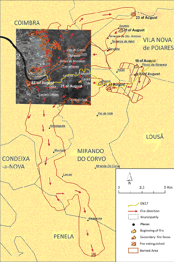
Source: Lourenço (coord.) 2007, 75, adapted.
Fig. 12 - Diagram showing advance of forest fires which
started
in Vila Nova de Poiares on 19 and 21 August.
The glowing particles, carried by the wind - occasionally gusting strongly - continued to ignite new fire focuses, ahead of the main front of the flames. These grew extremely quickly and were then generally caught up by that front and incorporated into it. In a trice, in the face of this overpowering march, small eucalyptus groves inside the urban mesh were catching fire, while the flames from the main front were being contained near the houses on the periphery of the city, to its east (Photo 5).
Not only did it all happen extremely quickly, but it happened during the night and at the end of a weekend. During that night, the villages of Zorro, Palheiros and Carvalhosas, to the south of the river, and Torres do Mondego and Casal do Lobo, to the north, all had to be evacuated.
With the change in wind direction, the red hot particles began to start new fires, once again to the south of the river Mondego and to the west of the zone previously burnt, to the west of the confluence of the river Ceira with the Mondego. In fact it was just on the outskirts of the Sobral Cid Hospital, from which the bedridden patients were evacuated as a precautionary measure at about 2 o’clock on the morning of the 22nd.
In the meantime, back-up from the nearest fire brigades started to arrive. But in spite of the growing amount of means and resources, in the context of the confusion which arises in these urban-forest interfaces, there was enough fire to keep everything occupied. The help of the locals, who lived through long hours of anguish, was in many cases crucial, since the firefighters could not be everywhere at once.
It was only at daybreak on the morning of the 22nd that it became truly clear how the fire had covered such a vast area within the urban perimeter of the city of Coimbra, in such a short space of time, and with even greater ferocity than in 1995 (Lourenço, 1999).
The fire continued on its devastating march heading south, covering the whole of the municipality of Miranda do Corvo. Its destructive progress was finally halted in the municipality of Penela.
In order to remove all doubt we will now illustrate two of the causes which contribute to large forest fires and try to show how simple steps can be taken to tackle them.
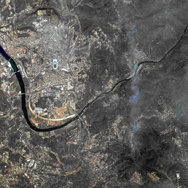
Source: http://www.scrif.igeo.pt/satelite.htm (for politeness of the European Space Imaging)
Photo 5 - Satellite image (IKONOS) from 24/08/2005, showing the whole burnt area to the east of Coimbra and how the fire penetrated the urban area.
The explanation given first and foremost by the media for many of the forest
fires in 2005 was frequently that of arson, leaving one to assume that this
was the main cause behind large forest fires. But in fact this bears almost
no resemblance to the truth. Even in those cases where it may be true, several
other factors will generally have converged to allow the fire to develop, and
will therefore also help explain the ineffectiveness of the first intervention.
There factors may well arise from the manifest absence of land-use planning
mentioned earlier.
And so, particularly at the interfaces where the urban space gradually opens
out into the forest, the forest fire problem is due almost entirely to the failure,
first, to implement any form of land-use strategy, and then to the lack of planning,
at the urban level, at the level of the forest and, in particular, at the level
of protecting the forest against fires.
Therefore, in many of the municipalities of the Porto district, mentioned above, as in all too many others across the country, urban growth sprouts up along networks of paths which penetrate or traverse forests, where the construction of industrial parks, leisure infrastructures, factories, works sites and even homes takes place on the edges of and within forests. Ordered housing areas, possibly even with some infrastructures which allow for a certain level of protection against fires, only appear very rarely. More often than not, buildings are surrounded by spaces containing a great deal of plant fuel load and other inflammable materials which significantly increase the level of danger in the event of a forest fire (Lourenço & Rainha, 2006).
It is both curious and worrying to note that, in spite of the danger to which these houses and other infrastructures are exposed, one only rarely sees measures or actions taken to lessen the risks to these buildings in the event of a forest fire. Such measures consist, firstly, of creating and afterwards maintaining protection belts outside the clusters, isolated houses and other buildings and infrastructures. In addition the fuel load should be reduced by clearing the land within the clusters which are awaiting development, installing water networks for supplying fire hydrants, which are not always kept operational and so cannot be used if needed.
If these simple steps are not taken, the consequences and anguish caused are well known, and are widely exploited by the media, which turns them into favoured targets, given the dramatic images and reports which such situations afford. Moreover, this implies the diversion of resources to protect buildings, rather than using them to combat fires in the forests.
In effect, whenever a report of an event reveals that there are houses in danger, extensive resources are mobilised that are not always proportional to the actual risk. On occasion, the direct fight against the fires suffers as a result of resources being used to defend houses, thus allowing the fire to spread further out of control.
It is obvious that the defence of property and possessions is a priority. But if these were properly safeguarded beforehand, it would often be easier to ensure their protection, not only in safer conditions, but also at the cost of fewer resources.
In spite of the extensive news coverage and the shocking images televised, which have sadly been repeated over the last few years, it has been realised that the people responsible for land-use management and planning, the municipal civil defence services and the majority of people who live in forest areas or on their outskirts, were quite ignorant (and many still are) of the risks they run, regarding forest fires. The absence of land-use planning in this country leads to the dispersion of land resources, shifting them away from fighting the forest fires. This brings us to another message, which is also frequently publicised by the media, and that is that the protection of housing is important only when the forest is alight, which is clearly not the case.
This situation is aggravated in circumstances where, together with the abandonment of forest areas, the farmland adjoining buildings has also been abandoned. All kinds of materials are very often dumped, nearly always illegally. Real rubbish tips have occasionally been created, and these substantially worsen the precarious safety conditions during firefighting operations. At these urban-forest interfaces, any focus of fire can turn into a complex civil defence exercise, given that no-one knows the contents of these dumps, which can be found both within the built environment and in adjoining forest areas.
In many situations, the problem does not stem from the lack of means for fighting fires, as is often claimed, but rather from the need to divert them to situations caused by the carelessness of citizens who have failed to protect their property, and by the State itself, which fails to control these situations, many of which are real assaults on the environment. If these simple steps were taken, it would not be necessary to mobilise firefighting resources for this purpose, thus avoiding the costly use of human and financial assets which, in our opinion, would be far better employed in preventive work.
However, the media pressure which has meanwhile taken hold is today so powerful that it has created the psychological conditions in the agents operating in this sphere, such that they sometimes forget the need to protect the forest and expend all of their energies on defending houses. Resources are thus committed which would have been better employed in other locations, where they could well have prevented the flames from reaching houses if they had been deployed to the fire fronts early enough.
In this media context, everything seems to be more important than protecting the forest!
One of the most important causes of the forest fire situation described above in 2005 was the projection of red hot particles which easily started new fires, because the combustible residues were extremely dry, and fine, thanks to that year’s drought. The dryness was in many cases crucial to accelerating the spread of the fires.
Another cause of fires, which is also non-deliberate but which the media (due to ignorance of the true cause) often labelled as arson, is related to the re-igniting of fires which were not properly extinguished, because the damping-down was not fully consolidated. Some people insist they do not accept that re-ignition occurs, because this is a compromise and it is preferable to place the blame on presumed (invisible) arsonists, but it has existed for a long time and is more common than might be thought (Table 1).
We have the greatest respect and admiration for everyone who is involved in fighting fires, often risking their own lives. Similarly, we also find it strange whenever some people do not act appropriately, damaging the image of those who are most competent and committed. In the circumstances described, this behaviour almost always results in the development of large fires which jeopardises the quality of the work of the firefighters.
In spite of the inherent costs of firefighting which result from these situations, blame is not apportioned and so no sanctions are applied. These could simply include the temporarily removing from the theatre of operations of everyone lacking the appropriate physical capabilities or training to carry out their tasks, that is, those who do not hold a certificate suited to their respective level of operation, acknowledged by competent body. And until they acquire such a certificate, they should not be allowed to take part in the forest firefighting speciality. This simple measure alone would help to bring about a change in procedures!
As in previous years, in many of the incidents that occurred in 2005, forest fires were controlled barely a few metres from roads, paths and forest trails or houses. Bearing in mind that between these infrastructures and the burnt areas there were strips of land containing combustible materials (dead or alive, and in this case, also fairly dry due to the warming up to which they were subject), after a few hours these could rekindle and give rise to new fires.
Therefore, although the initial control of the fires was generally conducted very effectively, procedures at the level of damping-down and its aftermath surveillance were often ineffective, even when the perimeter of the initial fire head was no more than a few dozen metres.
Bearing in mind that the necessary safety conditions (favourable winds and available resources) are often in place, it is essential that the teams encourage the burning of the green belts and/or dead combustible materials adjacent to the forest paths and trails in order to reduce the likelihood of their re-igniting.
When this was not done, many fires re-ignited and, in some municipalities, more fires started through re-ignition than there were initially – a fact which should merit deep consideration.
We argue for the application of measures which are simple and inexpensive, and yet could still be highly effective, if implemented. Why wait longer?
The conclusions drawn from the analysis carried out here make it possible to outline a series of considerations on the causes of fires which, from the outset, cannot be reduced to the commission of criminal acts, as seemed to be concluded by many of the news reports and direct televised broadcasts just a few years ago. They are far more likely to have other causes, and this clearly highlight some of the areas where intervention is not only possible, but indeed desirable and urgently needed.
The first observation is drawn from aspects which, in general, are linked to land-use planning, particularly at the urban-forest interface, and focusing on the planning and management of forested areas.
Another set of equally important factors is essentially tied to people’s habits and the practices of forest firefighting teams, which need to be changed.
Some habits could be easily changed, once people are really aware of the risks and can see the quite unnecessary dangers that they pose. These could be conveyed through awareness campaigns aimed at the respective, specific, target publics, and we would pinpoint those situations for which the greatest care is needed to create safe conditions: burning of agricultural and forest waste, by farmers; fires set by shepherds to renew pastures; use of fumigators by bee-keepers.
Another careless behaviour that can easily be prevented is the bad habit some smokers have, which is to throw smouldering cigarette ends out of their vehicles as they drive along. Some of these land on the verges and can set light to dry weeds and grasses, and this then develops into a forest fire. The solution here is to put the cigarette ends in the vehicle’s ashtray, and also to cut the roadside verges and remove the weeds, before the time of the year when forest fires are most likely to occur.
A third set of procedures that should be changed concerns the lack of safety conditions of many houses that stand, isolated, in the middle of a forest, or which have been built on the edge of urban areas and are surrounded by woodland. They are in danger either because there are no fire breaks around them, or because the fire breaks have not been maintained, and so the solution is, in the first case, to construct fire breaks, and, in the second, to clean them from time to time, as necessary.
In terms of firefighting practices, in addition to those stemming from the failure to provide a great many firefighters with specialised training, the almost exclusive use of water and the scant or non-existent use of manual tools, like crawler machines, seriously compromises the efficacy of damping down operations, leading to the re-igniting of fires. This would be easily avoided with the combined use of these two techniques, using hand tools or machines to create a line interrupting the combustible material and then using water to cool any vegetation which may still be smouldering.
Lastly, it should not be ignored that the drought which lasted throughout 2005, and which was an abnormal situation, highlighted some of the known weaknesses of the system for protecting forests against fires.
Portugal must stop being a key news story abroad because of its forest fires. It should become known, though this is not newsworthy, for the solutions we have found to solve this terrible problem. A problem which all too often begins at the urban-forest interfaces and which we have only failed to eliminate, or at least minimise, over the last quarter century because we do not want to invest in the simple things which could have been done in those interface areas. We have always preferred to wait for the aeroplanes and other expensive resources which we are unlikely ever to have in large enough numbers to tackle the problem successfully.
Almeida, R., & Lourenço, L. (2004) – What happens in the hot Summer of 2003, Forest Fire Net, Associated European Center for Forest Fires (ECFF), Atenas, n.º 2, 17-31, http://www.civilprotection.gr/ecff/docs/FFNet_%202.pdf
Beigley, M., & Quinsenberry, M. (USDA Forest Service) (2004) Observações e Recomendações, Relatório do Projecto de Cooperação Técnica – Incêndios Florestais em Portugal. Lisboa, 11 (unpublished);
Beringer, J. (2000) – Community fire safety at the urban/rural interface: The bushfire risk. Fire Safety Journal, vol. 35, issue I, July, 1-23;
Caballero, D., Beltrán, I., & Velasco, A. (2007) – Forest Fires and Wildland-Urban Interfaces in Spain: Types and Risk Distribution, IV International Wildfire Conference, Seville, 13-17 May, T5, 1-14;
Carvalho, J. B. (2003) – Codificação e definição das categorias das causas dos incêndios florestais – DGRF, Direcção Geral dos Recursos Florestais, Lisboa, 9, http://www.dgrf.min-agricultura.pt/portal/prevencao-a-incendios-dfci/estatisticas/estatisticas-1996-2006-por-freguesia/?searchterm=codificação%20causas ;
Correia, S. (1994) – Determinação das causas de incêndio florestal. Uma metodologia. Actas do II EPRIF, Encontro Pedagógico sobre Incêndio Florestal, Universidade de Coimbra, Coimbra, 141-151;
Coutinho, J. M. P. (2006) – Causas de ignição humanas dos incêndios florestais. Relatório final do Projecto de Investigação CIES-ISCTE/DGRF, Centro de Investigação e Estudos de Sociologia do Instituto Superior de Ciências do Trabalho e da Empresa, Lisboa, 96 (unpublished);
Cravidão, F. (1989) – A população da área do incêndio de Arganil (1987) – Análise geográfica. Grupo de Mecânica dos Fluidos, Coimbra, 38;
DGRF, Direcção Geral das Florestas (2003) - Incêndios Florestais – 2003, 13.º Relatório Provisório (01 Janeiro a 31 de Outubro), Divisão de Protecção e Conservação Florestal, DGRF, Lisboa, 12,;
DGRF, Direcção Geral dos Recursos Florestais (2004) - Incêndios Florestais – 2004, 16.º Relatório Provisório (01 Janeiro a 10 de Outubro), Divisão de Defesa da Floresta contra Incêndios, DGRF, Lisboa, 10, ;
DGRF, Direcção Geral dos Recursos Florestais (2006) - Incêndios Florestais – Relatório de 2005, Divisão de Defesa da Floresta contra Incêndios, DGRF, Lisboa, 26, ;
DGRF, Direcção Geral dos Recursos Florestais (2007) - Incêndios Florestais 2006 – Relatório Final, Defesa da Floresta contra Incêndios, DGRF, Lisboa, 35, ;
Ganho, N. (1994) - Risco de incêndio florestal em áreas urbanas e periurbanas - O exemplo de Coimbra. Actas do II EPRIF - Encontro Pedagógico Sobre Risco de Incêndio Florestal, Coimbra, 97-116;
Gonçalves, A. J. B. (2006) - Geografia dos Incêndios em Espaços Silvestres de Montanha – O caso da serra da Cabreira. Dissertação de Doutoramento em Geografia Física e Estudos Ambientais, Instituto de Ciências Sociais, Universidade do Minho, 438 + 150;
Granger, K., Luxton, D., & Berechree, M. (2000) – Bushfire risks, in Natural hazards and the risks they pose to South-East Queensland, Australian Geological Survey and Bureau of Meteorology, Chapter 11, 11.1-11.11;
IM, Instituto de Meteorologia (2003) – Onda de calor (29 de Julho a 14 de Agosto de 2003), retrived from the Web October 11, 2003, http://www.meteo.pt/TemperaturaArMeses/julhoagosto 03b.htm
Lourenço, L. (1992) — Aspects économiques, sociaux et culturels des incendies de forêt et de friche au Portugal. Seminaire sur la prévention des incendies de forêt, l'amenagement du territoire et les populations, Atenas, 124-135;
Lourenço, L. (1995) – Meio geográfico e fogos florestais. Relações de causa-efeito. Actas, II Congresso da Geografia Portuguesa, APG, Lisboa, 177-183;
Lourenço, L. (1999) – Coimbra e os riscos naturais. Passado e presente, Cadernos de Geografia e Actas do I Colóquio de Geografia de Coimbra, número especial, Coimbra, 37-43;
Lourenço, L. (2006a) – Incêndios Florestais. Algumas reflexões sobre prevenção e mitos do combate, Territorium, 13, Riscos – Associação Portuguesa de Riscos, Prevenção e Segurança, Coimbra, 59-70, http://www.nicif.pt/riscos/Territorium13.htm;
Lourenço, L. (2006b) – Geografia dos Incêndios Florestais em Portugal continental Actas des Jornades sobre terrasses i prevenció de riscos naturals, Palma de Mallorca, 33-56;
Lourenço, L. (2007) – Incêndios florestais de 2003 e 2005. Tão perto no tempo e já tão longe na memoria. Riscos Ambientais e Formação de Professores/Actas das VI Jornadas Nacionais do Prosepe, Colectâneas Cindínicas VII, Coimbra, 1991. http://www.nicif.pt/estudos%20cindinicos%207.htm
Lourenço, L. (Coord.) et al. (2005) – Plano Nacional de Defesa da Floresta contra Incêndios, Agência para a Prevenção de Incêndios Florestais, Miranda do Corvo, II vol., 236+387;
Lourenço, L., & Rainha, M. (2006) – As mediáticas ‘mãos criminosas de incendiários’ e algumas das “lições dos fogos florestais de 2005”, em álbum fotográfico. Contributo para a desmistificação dos incêndios florestais em Portugal, Territorium, 13, Riscos – Associação Portuguesa de Riscos, Prevenção e Segurança, Coimbra, 71-82, http://www.nicif.pt/riscos/Territorium13.htm ;
Mendes, C. (2003) – Incêndios Florestais e Onda de Calor. Análise do período entre 27 de Julho e 15 de Agosto de 2003. Relatório Preliminar. Divisão de Riscos Naturais e Tecnológicos da Direcção de Serviços de Prevenção e Protecção, Serviço Nacional de Bombeiros e Protecção Civil, Carnaxide, 27 (unpublished);
Vieira, P. A. (2006) – Portugal: O vermelho e o negro. A verdade amarga e a dolosa realidade dos incêndios florestais. Dom Quixote, Lisboa, 469.
Websites Relating to Bushfire Management referred to in Article
http://www.fire.uni-freiburg.de/GFMCnew/2005/08/0806/20050806_port.htm
http://images.google.com/imgres?imgurl=http://cduvalongo.blogs.sapo.pt/arquivo/valongo.JPG&imgrefurl=http://cduvalongo.blogs.sapo.pt/2005/09/&h=284&w=381&sz=13&hl=pt
http://images.google.com/imgres?imgurl=http://earthobservatory.nasa.gov/NaturalHazards/Archive/Aug2005/Portugal.TMOA2005216_lrg.jpg&imgrefurl
http://www.skyscrapercity.com/showthread.php?t=324790&page=2
| Comments to Trauma.Webmaster@massey.ac.nz Massey University, New Zealand URL: http://trauma.massey.ac.nz/ |
Disclaimer
Last changed
January 5, 2009
|