 |
Realising the Potential of Land-Use Planning
|
| |
Realising the Potential of Land-Use Planning
|
Bruce GlavovicEQC Fellow in Natural Hazards Planning,
|
Julia S. Becker &
|
The New Zealand policy and legal setting for land-use planning provides a robust foundation for reducing hazard risks. But much remains to be done to improve hazards planning policy and practice in New Zealand. This article starts by describing the setting within which natural hazards planning takes place. Five critical issues are identified and priority actions are recommended for realising the potential of land-use planning to reduce hazard risks: (i) Improve understanding about the nature of hazards; (ii) Prioritise Reduction measures; (iii) Provide national guidance for communities exposed to repeat events and confront the relocation issue; (iv) Mainstream climate change adaptation; and (v) Facilitate cooperative hazards governance.
New Zealand communities face a wide range of natural hazards – from flooding to landslides, coastal storms and erosion, severe winds, snow, droughts and the potentially catastrophic impacts of earthquakes, tsunamis and volcanic eruptions (ODESC, 2007). To make matters worse, New Zealanders are increasingly at risk because, firstly, the protective function of natural systems has been undermined by the transformation of the natural environment to make way for agriculture and cities and towns (Pawson & Brooking, 2002). Secondly, urbanisation and physical development patterns have concentrated the population in cities and towns, many of which are vulnerable to hazards, notably frequent flooding events and coastal hazards as well as low-frequency events such as volcanic, seismic and tsunami risks. Climate change compounds the risks many communities face, especially those in floodplains and along low-lying coastal margins due to the anticipated increase in the intensity and frequency of storms and sea level rise (Bell et al., 2002; IPCC, 2007; Jacobson, 2004, 2005; MfE, 2008a).
This article briefly describes the New Zealand setting for natural hazards planning, including key institutional and legal provisions [Endnote 1]. Critical issues are identified and priority actions recommended for unlocking the potential of land-use planning to reduce hazard risks in New Zealand. The authors identified these critical issues and priority actions based on experience working in this field in New Zealand, including past and ongoing research contracts and consultancy work for a wide range of stakeholders, and were informed by recent publications (e.g., CAE, 2005; Ericksen, 2005a, b; MfE, 2008b). These critical issues and priority actions are presented to stimulate thinking, discussion and action. Much would be gained if government initiated a deliberative process with key roleplayers to systematically identify the most important issues and priority actions for natural hazards planning in New Zealand. Such a process would be very fruitful quite aside from the list of issues and actions generated. It would help to build the shared understanding and common purpose that is central to hazard risk reduction and building community resilience.
In the past, protecting communities was achieved through centralised government action and reliance on efforts to ‘control the hazard,’ for example, through protective works for flood prone communities that were subsidised by central government (CAE, 2005; Ericksen et al., 2000; MfE, 2008b). Insurance and relief measures have also been and continue to be used to enable communities to bear the burden of hazard events. But reliance on such works can be devastating if hazard events exceed design parameters; and relief measures do little to alleviate the tragedy of natural disasters. Land-use planning can play an important role in reducing hazard risks by locating new development in less risky areas; essentially keeping people away from perils as opposed to having communities rely on controlling the physical hazard threat or being ‘rescued’ in the aftermath of an event (Burby, 1998; Mileti, 1999).
Many different organisations and institutions have an interest in or are affected by natural hazards planning processes, including different spheres and agencies of government, civil society, the private sector, lifeline utilities, and research and educational institutions. These stakeholders have divergent interests, some of which may conflict with the goal of hazard risk reduction. Ensuring that there is common understanding about who these stakeholders are and reconciling their different interests constitutes the major challenge for improving natural hazards planning practice. Local communities often downplay the importance of hazards relative to day-to-day concerns. Furthermore, it is difficult for local communities to counter new development proposals that promise economic benefits, but may jeopardise public safety and community sustainability, merely on the grounds of low probability hazard risks. Economic growth, corporate interests and ‘new development’ are given priority and private property rights are held virtually sacrosanct (Bührs & Bartlett, 1993). Narrow, short-term interests thus often prevail over community safety and sustainability (Ericksen, 2005a, b). Whilst increasing attention is being focused on hazard risk reduction through land-use planning and building controls (Ericksen, et al., 2000; Kerr, 2005), there is still a tendency to rely on protective works and to expect rescue and relief in the aftermath of an event.
The institutional and legal regime governing land-use planning frames and largely determines the efficacy of natural hazards planning in New Zealand. The planning regime was radically transformed through extensive institutional and legal reforms in the late 1980s and early 1990s, notably through the introduction of the Resource Management Act 1991 (RMA) (Bührs & Bartlett, 1993; May et al., 1996; Memon & Perkins, 2000), and since 2002 with the enactment of the Local Government Act (LGA). These far-reaching and innovative reforms held much promise. But this promise has not been realised fully due to shortcomings in governance, and inter-governmental cooperation in particular (Ericksen, et al., 2004; Perkins & Thorns, 2001; Schofield, 2007). Significant and contentious reforms are now underway with the election of a new government in November 2008. Whatever direction these reforms take, it is clear that central government needs to assume a more effective role in enabling local government and communities to reduce hazard risks and build community resilience.
Notwithstanding the shortcomings of prevailing governance arrangements affecting planning, the institutional and legal regime for natural hazards planning in New Zealand has a solid foundation in policy and law (MfE, 2008b; ODESC, 2007). There has been devolution of functions and an emphasis on local authorities assuming responsibility for local matters, including natural hazards planning. However, since the above-mentioned reforms, which are predicated on a user-pays approach, local communities now have to pay for protective works - which are beyond the means of communities with a small ratepayer base. Central government agencies assist communities in preparing for and managing hazard risks. When an event exceeds local capacity, central government helps communities recover. The planning framework established by the RMA and LGA makes an explicit connection between community planning for sustainability and natural hazard risk reduction through devolved responsibilities and a cooperative governance system. Planning provisions through the LGA require the development of a 10 year Long Term Council Community Plan (LTCCP) that includes a community vision and a complementary Annual Plan to translate this vision into practical reality. The RMA requires Regional Councils and Territorial Authorities [Endnote 2] to identify and avoid or mitigate natural hazards through a system of policies, plans and consent approval processes. However, there continues to be considerable variability in how hazards are being integrated into planning provisions – be they Regional Policy Statements, or Regional or District / City Plans. Much remains to be done to fully align regional and territorial authority planning processes (Ericksen et al., 2004) and to prioritise hazard avoidance through proactive planning efforts (Becker & Johnston, 2000). Nonetheless, these planning provisions are complemented by the Civil Defence Emergency Management Act 2002 (CDEMA) which aims to build community resilience through an all-hazards approach that is rooted in a ‘4R’ (namely Reduction, Readiness, Response and Recovery) emergency management approach. Alignment and integration of planning and emergency management measures is essential for effective natural hazard risk reduction (Saunders et al., 2007).
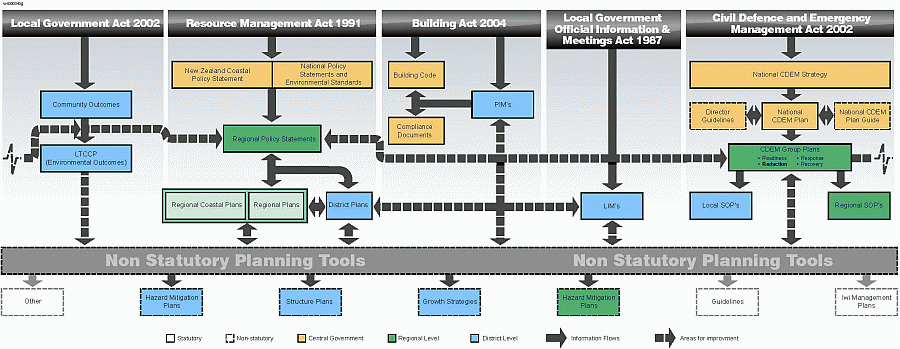
Figure 1: Primary natural hazard responsibilities and relationships
for natural hazard planning in New Zealand:
Opportunities for building synergies
(Source: Glavovic et al. in press)
LTCCP = Long Term Council Community Plan;
PIM = Project Information Memorandum;
LIM = Land Information Memorandum;
SOP = Standard Operating Procedure
Achieving better cooperative hazards governance is a complex and difficult undertaking given the wide array of interested and affected parties involved; and given that important legal provisions are spread out across various statutes with inevitable gaps, overlaps and inconsistencies that need to be more carefully aligned (see Figure 1; discussed further below). This challenge is ‘not new’ and existing government agencies and other stakeholders are taking a variety of steps towards addressing this challenge. In short, these provisions need to be viewed as a whole and together provide the foundation for building sustainable, hazard-resilient communities, and provide planners with a range of tools to avoid and mitigate hazard risks.
There is a range of tools and mechanisms available to planners for hazard risk reduction. These include regulatory planning tools, which under the RMA include National Policy Statements, Regional Policy Statements, Regional Plans, District Plans, and the resource consent process. There are also provisions under the Building Act 2004 for making publicly available hazard information about a particular site in a Project Information Memorandum (PIM), which is required for building consent. The Building Code and related provisions also influence the design and construction of buildings and structures for improving hazard resistance (i.e., specifically earthquake and wind loadings). Under the Local Government Official Information and Meetings Act 1987 (LGOIMA), a Land Information Memorandum (LIM) can be requested (usually before purchasing a property) which includes information about any hazards the Council is aware of that may affect the parcel of land. Other tools include hazard registers; insurance provisions that planners can leverage to influence patterns of development; set-back lines and ‘no build’ zones; conservation easements and land swaps; consents; structure plans; growth strategies; iwi management plans; emergency management warning and evacuation planning; education; research; and advice and advocacy (see e.g., Burby, 1998; Tonkin & Taylor, 2006). Financial incentives (or disincentives) for risk reduction is another tool available to Councils, but it is not widely used in prevailing planning practice. There is a compelling need to raise awareness about the range of planning tools available to reduce hazard risks, as several have tremendous potential but are little known and seldom used. It is important to draw upon sound legal and scientific advice to ensure effective use of these tools.
In sum, the New Zealand institutional and legal setting provides a robust and enabling foundation for building resilient communities, and provides planners with a range of tools to avoid and mitigate hazard risks. We consider the main challenge to lie in improving cooperative governance for community sustainability and resilience – which lies at the heart of natural hazards planning practice. We identify five critical issues and associated priority actions that need to be taken to improve future natural hazards planning in New Zealand (see Table 1 for a summary of issues and actions).
Table 1: Critical issues and priority actions for realising the potential
of land-use planning
to reduce hazard risks in New Zealand
Improve understanding about natural hazards |
Prioritise Reduction measures |
Provide guidance on repeat events and relocation |
Mainstream climate change adaptation |
Facilitate cooperative hazards governance |
|---|---|---|---|---|
|
|
|
|
|
Recent hazard events, such as the 2004 Lower North Island floods (Fuller, 2005; Goodwin, 2005), 2005 debris flows in Matata (Bassett, 2006), the 2007 and 2008 floods in Northland (Anon., 2007) and 2007 Gisborne earthquake, highlight the tendency for communities to focus attention on hazards only when they experience an event or face a tangible threat. Otherwise, hazards risks are downplayed relative to more immediate concerns. Much remains to be done to improve understanding amongst the public, community leaders and professionals about the nature of hazards and their potential impacts; and then to translate this understanding into actions that promote community preparedness and resilience. It is important to recognise that hazard risk is a product of the physical peril and social vulnerability of communities (Wisner, et al., 2004). Recognising the interactive nature of the physical threat with human use and social conditions is likely to lead to measures that endeavour to keep people away from perils, for example, through land-use planning decisions that avoid locating new development in high risk areas. At a very basic level, there is a need to improve public understanding about terms that are commonly used but easily misunderstood (see e.g., Ericksen, 2005a, Saunders & Glassey, 2007).
Priority actions:
At present, the CDEMA and supporting Strategy, Plans and Director’s Guidelines do not focus adequate attention on Reduction or the pivotal role that land-use planning plays in building resilient communities. It is assumed that Reduction measures will be taken through other planning related legislation as per the RMA and LGA. But Reduction has fallen between legislative ‘cracks’ (Saunders et al., 2007). This shortcoming is now recognised and there is growing appreciation in the emergency management sector about the important role that land-use planning plays in hazard avoidance and risk reduction (Saunders & Becker, 2008). The planning profession also needs to focus increased attention on hazards and the relationship between planning and emergency management. Particular attention needs to be focused on mainstreaming natural hazards, and hazard avoidance and risk reduction, into day-to-day planning processes. In addition to improved policy and legal alignment, there is a compelling need to foster good communication between emergency managers and planners to ensure that every effort is made to prioritise Reduction, especially in situations where there are opportunities to avoid locating new development in high risk areas.
Priority actions:
Many New Zealand communities are exposed to high-frequency repeat events such as riverine flooding and coastal erosion and storms. In some cases, these hazard risks will be exacerbated by climate change. It is not desirable to deal with this issue on an ad hoc basis in the aftermath of events. Difficult decisions are going to have to be made about how to improve the safety and sustainability of at-risk communities. Particular attention needs to be focused on removing incentives that encourage people to remain at risk, such as insurance contracts that encourage people to rebuild in a high risk location or renovate a damaged building to the state it was prior to an event. At the very least, new development should be concentrated in less risky locations; and where necessary, and with careful consultation and planning, it may be necessary to relocate especially vulnerable communities. The sociological consequences of relocating communities are, however, profound and demand very careful consideration. The relocation of Kelso, a small town of less than 200 residents, in the Clutha district of Otago is instructive (see summary in Becker et al., 2008). The town was impacted by severe flooding in 1978. The town had just recovered when 15 months later devastating floods struck again. The size of the town meant that flood mitigation works were not supported by local councils on a cost benefit basis. The decision was made by the townspeople to relocate to other settlements. The decision was made on a house by house basis with residents on higher ground wanting to remain and homeowners on the flood plain choosing to move. Some Kelso residents moved to the neighbouring town of Tapanui, others to Heriot. After the closing of the post office, town store and school, the town was abandoned by remaining residents. Former Kelso townspeople have held reunions since the town was abandoned, but the generations-old, close-knit community was unable to stay together. Pre-event planning following the 1978 flood may have helped the town to plan for a more united and community-sustaining relocation.
Priority actions:
Climate-related risks and impacts will need to be addressed through day-to-day community planning processes. Initial climate change impacts are likely to be experienced mainly in the form of climatic extremes. Hazard risk reduction measures to limit exposure to related extreme events will therefore be key to adaptation. Measures taken now will pay dividends as climate change impacts unfold in coming decades. Government, notably the Ministry for the Environment (MfE), is playing an active role in helping local authorities and communities understand the climate change issue, its likely impacts and mitigation and adaptation options. However, more attention and resources need to be focused on this critical issue.
Priority actions:
The basic institutional and legal provisions for natural hazards planning in New Zealand are well grounded. The fundamental challenge is to turn the existing policy rhetoric into tangible reality in local communities. In essence, this is a cooperative governance challenge that needs to be addressed on many levels and across the range of interests, institutions, laws, and professional practice.
Priority actions: Three aspects of the cooperative hazards governance imperative need to be highlighted.
Land-use planning plays a pivotal role in reducing hazard risks in New Zealand. But its full potential has yet to be realised. Ensuring that there is common understanding about who the key stakeholders are and reconciling their different interests constitutes the major challenge for improving natural hazards planning practice. Local communities often downplay the importance of hazards relative to day-to-day concerns. Narrow, short-term interests thus often prevail over community safety and sustainability. There is still a tendency to rely on protective works and to expect rescue and relief in the aftermath of an event. Consequently it is difficult to realise the full potential of land-use planning to reduce hazard risks. Building sustainable, hazard-resilient communities therefore remains elusive. On a positive note, increasing attention is being focused on hazard risk reduction through land-use planning and building controls. In sum, the New Zealand institutional and legal setting provides a robust and enabling foundation for building resilient communities, and provides planners with a range of tools to avoid and mitigate hazard risks. It facilitates an all-hazards, community resilience focused approach to natural hazards planning and emergency management that takes account of the ‘4 Rs’ in a devolved, cooperative modality that is geared towards avoiding and mitigating hazard risks. The fundamental challenge is to turn the existing policy rhetoric into tangible reality in local communities.
Five critical issues and associated priority actions are identified for realising the potential of land-use planning to reduce hazard risks in New Zealand. Firstly, there is a need to deepen and extend understanding about the nature of hazards, especially the social dimensions. Secondly, priority attention needs to be given to reducing hazard risks by keeping people out of harms way through prudent land-use decisions rather than trying to keep perils away from people through protective works and relying on ‘bail outs’ to help people recover. Thirdly, attention needs to be focused on how to deal with communities that are exposed to repeat events and the vexing issue of relocation. Fourthly, much remains to be done to mainstream climate change adaptation into community planning and decision-making. A National Policy Statement is needed to guide local communities in addressing this issue consistently. Finally, notwithstanding the strong foundation established in policy and law, the fundamental challenge is to facilitate cooperative hazards governance. Central government, in particular, needs to play a more effective role in enabling communities to reduce hazard risks. Community leaders, planners and emergency managers have pivotal roles to play in creating vibrant, sustainable and more resilient communities. These issues and actions are presented to stimulate thinking, discussion and action. The government should initiate a deliberative process with key roleplayers from the public and private sectors, civil society and the research community to systematically identify the most important issues and priority actions for natural hazards planning in New Zealand. Such a process would help to build the shared understanding and common purpose that is essential for reducing hazard risks and building community resilience.
The authors would like to acknowledge the support from the Foundation of Research, Science & Technology’s ‘Hazard & Society’ research programme; and advice from Dr David Johnston of the Massey University/GNS Science Joint Centre for Disaster Research. Bruce Glavovic would like to gratefully acknowledge the support of the Earthquake Commission to undertake this research.
Anonymous. (2007). Flood brings call for greater RMA powers. New Zealand Local government. July 2007, 2.
Bassett, T. (2006). The Matata debris flows, 18 May 2005. Paper presented at 1st International Conference on Monitoring, Simulation, Prevention and Remediation of Dense and Debris Flows, 2006 Rhodes, Greece, WIT Transactions on Ecology and the Environment. 90, 363-370.
Becker, J. & Johnston, D. (2000). District Plans and Regional Policy Statements. Planning Quarterly. September 2000, 22-23.
Becker, J. & Saunders, W. (2007). Enhancing sustainability through pre-event recovery planning. Planning Quarterly. March 2007, 14-18.
Becker, J., Saunders, W., Hopkins, L., Wright, K. & Kerr, J. (2008). Pre-event recovery planning for land use in New Zealand: An updated methodology. GNS Science Report 2008/11, 39p.
Bell, R., Hume, T. & Todd, D. (2002). Planning on sea level? Planning Quarterly. July 2002, 13-15.
Bührs, T. & Bartlett, R.V. (1993). Environmental Policy in New Zealand. Oxford: Oxford University Press.
Burby, R.J. (Ed.) (1998). Cooperating with Nature: Confronting natural hazards with land-use planning for sustainable communities. Washington, D.C.: Joseph Henry Press, 356p.
CAE (2005). Managing Flood Risk: The case for change. Report to the Flood Risk Management Governance Group. Christchurch: CAE. Available online: http://www.caenz.com/info/MFR/MFR.html
Ericksen, N. J. Dixon, J.E. & Berke, P.R. (2000). Managing natural hazards under the Resource Management Act 1991. In Memon, P.A. & H. Perkins (Eds.) Environmental Planning and Management in New Zealand. Palmerston North: Dunmore Press, pp 123-132.
Ericksen, N.J. (2005a). Hang-ups in flood hazard planning (Part I). Planning Quarterly. September 2005, 24-28.
Ericksen, N.J. (2005b). The hang-up in flood hazard planning (Part II). Planning Quarterly. December 2005, 28-32.
Ericksen, N.J., Berke, P.R., Crawford, J.L. & Dixon, J.E. (2004). Plan-making for Sustainability: The New Zealand Experience. Aldershot: Ashgate, 350p.
Fuller, I. (2005). February floods in the lower North Island, 2004: Catastrophe – causes and consequences. New Zealand Geographer. 61, 40-50.
Glavovic, B.C., Dryburgh, M., Chittenden, R. & Johnston, D. (Eds.) (2009). Proceedings of the 2nd Workshop on Emergency Management and Social Science Disaster Research in New Zealand: Deepening and Extending the Dialogue. Te Papa, Wellington, 8 th December 2008. GNS Science Miscellaneous Series 19, 22p.
Glavovic, B.C., Jones, K. & Johnston, D. (Eds.) (2008). Conference Proceedings: Emergency Management and Social Science Disaster Research in New Zealand. Wellington, 6 th December, 2007. GNS Science Miscellaneous Series 13, 30p. Available online: http://disasters.massey.ac.nz/pubs/GNS/Proceedings_EM_Workshop_Dec-07.pdf
Glavovic, B.C., Saunders, W.S.A. & Becker, J.S. (In press). Land-use planning for natural hazards in New Zealand: The setting, barriers, ‘burning issues’ and priority actions. Natural Hazards.
Goodwin, E. (2005). Lessons from mother nature. Planning Quarterly. September 2005, 2-4.
IPCC, (2007). Climate Change 2007: Impacts, Adaptation and Vulnerability. Working Group II Contribution to the Fourth Assessment Report of the Intergovernmental Panel on Climate Change. Parry, M.L., Canziani, O.F., Palutikof, J.P., van der Linden, P.J. & Hanson, C.E. (Eds.), Cambridge: Cambridge University Press, 976p.
Jacobson, M. (2004). Review of the New Zealand Coastal Policy Statement 1994 – Coastal Hazards: A review of the effectiveness of the NZCPS in promoting sustainable coastal hazards management in New Zealand. Vols. 1 and 2, Prepared for the Minister of Conservation. Available online: http://www.doc.govt.nz/publications/conservation/marine-and-coastal/review-of-the-new-zealand-coastal-policy-statement-1994-coastal-hazards/
Jacobson, M. (2005). NZCPS coastal hazard policies. Planning Quarterly. March 2005, 6-8.
Kerr, J. (2005). Civil defence and planning. Planning Quarterly. June 2005, 10-12.
Kerr, J., Nathan, S., Van Dissen, R., Webb, P., Brunsden, D. & King, A. (2003). Planning for development of land on or close to active faults. Wellington: MfE.
May, P.J., Burby, R.J., Ericksen, N.J., Handmer, J.W., Dixon, J.E., Michaels, S. & Smith, D.I. (1996). Environmental Management and Governance: Intergovernmental approaches to hazards and sustainability. London: Routledge, 254p.
Memon, P.A. & Perkins, H. (Eds.) (2000). Environmental Planning and Management in New Zealand. Palmerston North: Dunmore Press, 401p.
MfE (2008a). Preparing for Climate Change: A guide for local government in New Zealand. Wellington: MfE, 38p.
MfE (2008b). Meeting the challenges of future flooding in New Zealand. Wellington: MfE, 48p.
Mileti, D.S. (Ed.) (1999). Disasters by Design: A Reassessment of Natural Hazards in the United States. Washington, D.C.: Joseph Henry Press.
ODESC (2007). National Hazardscape Report. Wellington: ODESC, Department of Prime Minister and Cabinet, 139p.
Pawson, E. & Brooking, T. (Eds.) (2002). Environmental Histories of New Zealand. Melbourne: Oxford University Press, 342p.
Perkins, H. C. & Thorns, D. C. (2001). A decade on: reflections on the Resource Management Act 1991 and the practice of urban planning in New Zealand. Environment and Planning B: Planning and Design. 28 (5), 639-654.
Saunders, W. & Becker, J. (2008). Planning for natural hazard risk reduction in 2G plans – Looking beyond the RMA. Planning Quarterly. December 2008, 8-10.
Saunders, W. & Glassey, P. (Compilers) (2007). Guidelines for assessing planning policy and consent requirements for landslide-prone land. GNS Science Miscellaneous Series 7.
Saunders, W. Forsyth, J., Johnston, D. & Becker, J. (2007). Strengthening linkages between land-use planning and emergency management in New Zealand. The Australian Journal of Emergency Management. 22(1), 36-43.
Schofield, R. (2007). Alternative Perspectives: The future for planning in New Zealand. A discussion for the profession. Report Commissioned by the New Zealand Planning Institute, Draft: 13 August, 2007.
Schwab, J. with Topping, K.C., Eadie, C.C., Deyle, R.E. & Smith, R.A. (1998). Planning for post-disaster recovery and reconstruction. Planning Advisory Service Report Number 483/484. Chicago: FEMA and APA, 346p.
Tonkin & Taylor (2006). Natural Hazard Management Research Report. Available online : http://www.qualityplanning.org.nz/qp-research/natural-hazards-aug06/natural-hazards-aug06.pdf
Wisner, B., Blaikie, P. Cannon, T. & Davis, I. (2004). At Risk: Natural Hazards, people’s vulnerability and disasters. London & New York: Routledge.
[1] This article is a synthesis of a
more detailed analysis by Glavovic et al. (in press).(return
to text)
[2] For the purpose of this article,
central government refers to ministries and national level agencies. ‘Regional
councils’ refer to councils that have jurisdiction over a region, while ‘district
councils’ refer to councils that have jurisdiction over a district. ‘Unitary
councils’ combine both regional and city or district council functions.
City councils and unitary councils (e.g., Napier City Council, Gisborne District
Council) are included with district councils. In some instances ‘territorial
authority’ is used in place of ‘district/city/unitary council’ and ‘regional
authority’ is used instead of ‘regional council’. Local government
refers to both regional and district councils collectively. Regional Council
responsibilities are largely focused on environmental management whereas territorial
authorities have wider ‘day-to-day’ operational responsibilities. (return
to text)
| Comments to Trauma.Webmaster@massey.ac.nz Massey University, New Zealand URL: http://trauma.massey.ac.nz/ |
Disclaimer
Last changed
5 February, 2010
|